Water way to go, cats, dogs and a dodgy chopper

ribweir

The value of natural flood plains in the Dales was highlighted this week as they calmed the flow of rivers swollen by the excessive rain. New lakes were created here in Ribblesdale and throughout the region, saving communities further down the valleys from severe flooding (apart from where housing and industrial development has been erroneously allowed). As well as poor planning decisions there are other problems along riverbanks which have been created by humans. One is the way some landowners have banked up river edges to preserve or increase grazing land. In times of flood these act as barriers, and instead of letting rivers spread naturally, they speed up flow causing problems elsewhere. Weirs, built in many cases to help power old mills and create mill ponds, can also have an adverse effect. I watched the weirs and Langcliffe and Settle this week and saw first hand what they do when the rivers are high and fast-flowing. These artificial barriers raise water levels behind then cause a huge hydraulic jump afterwards. This causes great turbulence and danger in the worst conditions as witnessed in my picture. I’m all for capturing a river’s power to create electricity through well-placed turbines but I wonder if weirs are really necessary today? Also, in low water weirs are a barrier to fish migration and promote the growth of algae.
dogturd

There’s a popular walk from Settle along Watery Lane, but it proved a bit too watery last Sunday. I did manage this photo, however, where it seems the local allotment holders or perhaps fellow walkers are fed up with coming across doggie-do. I’m not sure whether the luminous paint looks worse than the dog mess but it certainly gets the message across.
inglequarry

There was still plenty of water at the top of the dale on Monday as I took a stroll in the Ribblehead region and around Ingleborough Nature Reserve. Signs of industry don’t have to be depressing and can create some interesting views.

kilningle

whernquarry

While I was below  Ingleborough I came across the Coastguard Sikorsky S-92 helicopter which had got into difficulties the previous day. The Cave Rescue Organisation, based in Clapham, requested help from the Coastguard when they were called out to a walker suffering chest pains on Ingleborough. However, the chopper developed a fault and the rescue team had to help stop the multi-million pound contraption from toppling over. The human casualty was stretchered off the hill and taken by Landrover then ambulance to hospital. It took a further three days to rescue the rescue machine.
rescue

My cat knows that when I get the map out its food supplier is planning to leave the house and also turn off the heating, so he does his best at sabotage.
catmap

I was only away an couple of hours though, dropping over the Newby Head into Widdale and Wensleydale to visit the bonnie Cotter Falls. Great Knoutberry also looked grand from this angle.
cotterf

gtknout

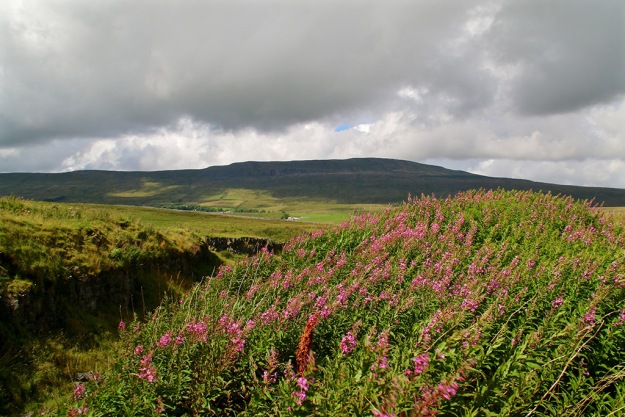
The temperature dropped dramatically on Friday, especially on the moors above Malham. I’d planned to walk through the dry valley of Watlowes (pictured below) over to Malham Tarn but the wind was fierce and the conditions, well, nithering.
watlowetop

The drive back from Kirkby Malham to Settle was strange – on one side, looking towards Pendle, the change from cloud to sun was amazing; inspirational skies for the artists among us.

inspire

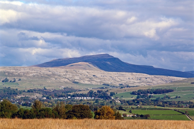
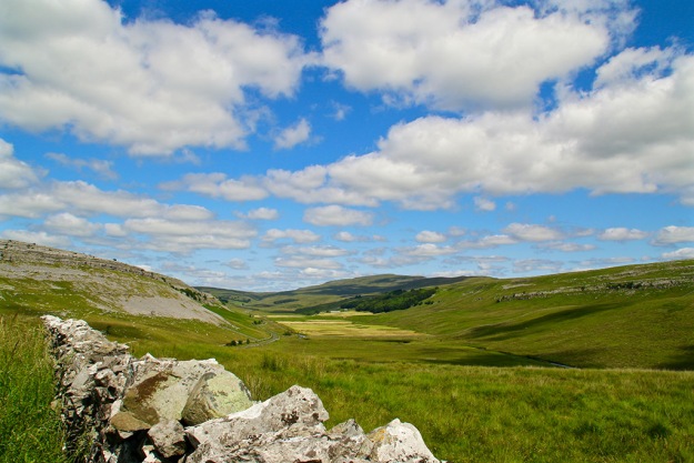
On the other side, as seen here with Ingleborough in the background and Warrendale Knotts in the foreground, was clear in bright blue sky.

ingwarren

Then the snow came yesterday so I headed back up Ribblesdale to do the Three Peaks (through photography from the car – I’m not that daft). The road up to Whernside was still pretty dodgy in the morning, especially where the sun hadn’t hit the road. The car told me the temperature was -1, goodness knows what it was like on top of those hills with the wind-chill.

whites

Three Peaks alternative & There must be Dales in Paradise

2peaksajbrownPrinted in the first Dalesman magazine (April 1939) is this little snippet describing an early Three Peaks walk – certainly not the route walkers would normally take today but an interesting one-way trek from Dent to Kilnsey.  A J Brown was a popular walking-book writer between the 1920s and 1950s. Striding Through Yorkshire, written in 1938, was one of his most popular books and can be picked up for a song on Amazon, Ebay or second-hand bookshops. He was a prolific walker – his book, Four Boon Fellows – a Yorkshire Tramping Odyssey (1928), was about a 100-mile walk he did one Easter weekend from Barnard Castle to Ilkley.
I’m not sure how far Brown’s Three Peak walk was – my guess is between 35-40 miles depending on the exact route. Not bad for a day’s trek which included three of Yorkshire’s highest mountains (and two pubs).
hurtlepotInterestingly, the route took in Weathercote Cave. I visited neighbouring Hurtle Pot (pictured) on Monday, close to the Ribblehead Viaduct Navvies church of St Leonard’s in Chapel-le-Dale. Nowadays Weathercote Cave, just a few hundred yards north of Hurtle Pot, following the mysterious disappearing Chapel Beck, can only be visited by gaining permission from the landownstlener.
In days gone by Weathercote Cave was a major tourist attraction –  visitors paid to view the spectacle, described as follows by Victorian writer Harry Speight:
‘The rocks here ascend to a vertical height of 108 feet, and the water is seen leaping from a large cavity 33 feet below the surface, and, expanding into a misty sheet of bright dissolving particles, drops 75 feet below with such tremendous violence into the stony whirlpool at our feet, that the noise and reverberation of the clashing waters render conversation an impossibility.’
The painter Turner visited the cave several times and it has been described as one of the wonders of England, especially when the beck is in full spate. However, the place was closed to the public in 1971 following the death of a visitor.
If you can’t obtain permission then the next best way to see Weathercote Cave is to visit
http://oldfieldslimestone.blogspot.co.uk/2013/02/the-darling-of-early-tourists-cave-this.html

Back to A J Brown – I was reminded of  him at Bill Mitchell’s funeral when one of Brown’s poem’s was mentioned. Anyone who loves the Dales will relate to Brown’s sentiments. Here is the full verse:
There must be dales in Paradise
or what would a dalesman do?
There must be dales in Paradise
to wander through and through
Bold Pen-y-gent and stern Whernside
are wondrous fair to see
And bonny Dentdale’s sunny slopes
are paradise for me.
To feel the rhythm of the pace that
wanders far and free!
To stride rough pastures of Cam Fell
and Langstrothdale so fair!
On steps above Wharfe’s waters bright
to breath the moorland air
Is nectar to tired townsmen who
the asphalt deserts flee.
But when we’ve done with wandering
amongst these well loved hills.
When Earth has loosed its hold on us,
its blessings and its ills.
We’ll find familiar pathways as
we reach fair Zion’s strand.
And our feet will know the blessings
of that beauteous Beulah Land.

Changing scenes, honours and farewells

caterpill

I didn’t know until this week that someone could become a ‘honorary Yorkshireman’. The old notion that unless your Yorkshire lineage stretched back as far as the Viking invasion you were, and always will be, considered as an offcumden, seems to have been chucked out with the bath water. On Monday, a bloke called Gary Barlow was awarded the distinction of Yorkshireman at what appears to have been a very un-Yorkshire-like OTT event put on by the Welcome to Yorkshire tourist organisation. Apparently, this Barlow fellow was once part of a popular beat-combo ensemble called Take That, and his credentials for being upgraded from Ordinary Cheshire Chap to Honorary Yorkshireman is due to him writing songs about our Calendar Girls. Now I’m not knocking Welcome to Yorkshire, who do a splendid job promoting the county, but I wonder if they are overstepping their jurisdiction here. Just who has the right to declare someone as being ‘Yorkshire’? And surely a pie and pea supper followed by a bingo session at a village hall would have been a more appropriate occasion to bestow such recognition? I wonder if Mr Barlow (Hon Yks) is now advocating a change of name to ‘Teck That Pal’?

Top picture: a giant caterpillar crawls out of the mist over the Settle landscape this week.

I attended the memorial service to a real Yorkshireman on Tuesday when the folk of Settle and district paid their respects to the late Bill Mitchell at St John’s. Bill attended the chapel for many years and was also a lay Methodist preacher in the district. The place was packed – he will certainly be missed in these parts but thankfully he leaves a great legacy.

pygtrig

I was itching to get out into the Dales by Thursday, and with the forecasters saying there could be some sunshine in the morning I found myself heading up Penyghent early doors. Just a quick trip up-and-down the pointy bit, starting from Dalehead Farm on the Stainforth to Halton Gill road. The forecasters didn’t mention there would be intermittent sun/cloud, which led to scene changes happening every few minutes. I got all the way to the top without meeting another soul, and ate my chocolate digestives alone beside a very windswept and mist-covered trig point. Neighbouring Fountains Fell was completely enveloped by cloud, while the view down Ribblesdale offered little by way of photography. You can just about recognise distant Littondale in the above picture during a brief cloud break-up.
pygwalk

In his lovely book, Summat and Nowt, Bill Mitchell says Penyghent from this angle looks like a marooned whale. He continues: “From the west it takes on the appearance of a recumbent lion with splendid mane. The nose-end enhances the view from the Ribble bridge between Settle and Giggleswick. A local philosopher spent so long contemplating this view that someone asked him what great thoughts had been going through his mind. He replied: ‘I was just thinking how much Penyghent resembles an upturned pudding dish’.”

pygsugar

I sometimes see the great hill as a partly-eaten layer cake. On Friday it looked like icing sugar had been sprinkled over (above). Last weekend those Met Office types had predicted snow on them thar hills by the end of the week. There was the aforementioned light coating on Penyghent and also on Whernside, but nothing on Ingleborough by the time I drove down Chapel-le-Dale.

Regular readers will know of my fascination for changing light in the Dales – and are probably fed up to the back teeth with me mentioning it – however, my passion was satisfied once more near Ingleton as the clouds parted and the landscape around Twisleton Scar briefly lit up. The spectacle is difficult to capture on a still photo and I wish I’d set the camera to video mode:

lightchange

I continued my journey home through Clapham along the old back road to find the village’s normally sedate falls sporting a whole new persona following the heavy rain. This time I did switch to video – there’s a 23-second movie here:
https://youtu.be/r_gqtnNMke0
If you can’t be bothered with going to Youtube for a video then here’s a still…
clapfalls

As I take in the beauty and peace of the Dales countryside I often wonder who will look after it for future generations, thus allowing them to do likewise. Judging by the actions of some fellow human beings recently, I can’t help but think we are still too primitive a species to be left in charge of this beautiful, fragile planet. We kill each other indiscriminately instead of adequately pooling wealth, resources and knowledge; we exterminate plants, birds and animals which keep Nature in balance; we continually destroy and exploit natural assets for selfish gain. Does anyone actually know what – if there is one –  the long-term goal is for humanity? Sometimes it’s difficult not to feel depressed about such issues. Thankfully I’m lucky enough to live in a peaceful part of the world and still have the freedom and ability to enjoy and appreciate its precious gifts.

Meanwhile, the rain continues to pour down here in Ribblesdale. Time to put on the waterproofs and see how my part of the world is coping…

Monoliths, aliens and a conflict of interests in the Dales

greatstonebw

Standing on top of Great Stone of Fourstones, which marks the Yorkshire border with that other county whose name escapes me, you can enjoy one of the best ‘driveable’ views of the south-western dales. The Three Peaks, Gragareth, Howgills and the distant jagged teeth of the Lakeland Fells are laid out before you. The 16ft-tall glacial deposit is the only one of four large stone outcrops remaining on this spot on Tatham Fell, near High Bentham – the others probably having been broken up for buildings and tools.  I wanted a view but not a trek on Wednesday and this monolith once again proved an ideal location. With a 200mm zoom lens I was able to make out the layered-cake effect of Ingleborough and capture Whernside looking particularly dominant above Twisleton Scar.

inglebwwen

wherntwis

After writing last week’s blog on Sunday I wandered up Ribblesdale and on to Stainforth Foss where dozens of people were on salmon-leap-watch. I wondered whether there would be any conflict here today, as just a few yards down river from the falls were two anglers … salmon fishing? Poaching? I didn’t stop to find out, but headed further downstream to Langcliffe where the colours on the riverbank and millpond stood out starkly against a drab sky.

ribbcolours

pondcolours

I reckoned this week would be one of the best for capturing the changing colours and I was right. On Monday I took a stroll around Malham Tarn – almost ignoring the tarn and concentrating on the surrounding bogland, shrubs and trees. The last time I’d been in this woodland I’d been startled by a deer but there was no sign this time.

malham1

malpath

The blue sky came out later and I got some good shots of the eastern side of Penyghent. I was also able to snatch some great scenes around home later that day in the evening sun.

pygcold

dramastain

spirelang

St John the Evangelist in Langcliffe might not have the history or ancient architecture of older dales churches but it is certainly a pretty Victorian building within well-kept grounds and it looks a picture when caught in the evening sun.

stjohn

At this time of year I like to raise my eyes above the area’s wonderful landscape and take in the ever-changing autumn sky. It’s been a treat this week with a variety of clouds, shades, and sunsets.  On Friday I sat  above Winskill and watched an invasion of aliens beaming up all before them … I woke up Saturday morning with ‘REJECT: Beyond Best Before Date’ stamped across my forehead.

abductions

Yesterday, after strolling by the Ribble in some glorious changing light, I drove up to the old road between Settle and Feizor to watch the sunset. I also waited as long as I dare for an unsteady hand-held night shot, to capture an outline of Ingleborough.

feizorsun

ingleoutline

Sunsets, tarns, top views, trains and therapy

This week I took far more photos of trains than would normally be considered as healthy. Therapy has been suggested but in my defence it was the final week of the summer steam train season on the Settle-Carlisle line which runs close to my home. I’ve bunched a few of my favourites from Wednesday and Thursday at the foot of the blog. The helicopter, however, was not the form of transport I was expecting to see while waiting at Ribblehead Viaduct.
viacopter
After writing my previous blog on Sunday I walked up Ribblesdale to Stainforth and back to Langcliffe via the scar and Lower Winskill. There’d been thunderous storms the previous night and a new ‘tarn’ emerged at the foot of the scar. I suspect that eons ago there was once a tarn covering much more of this area as well as in many other parts of the dale.
newtarn
The calm after the storm brought about a fabulous sunset, and once again the camera went into overdrive. Here are a couple of my favourites looking west from Winskill Stones.
winsunsetsheepsunset
Wednesday saw me visit one of the old quarries on Ingleborough Nature Reserve where Nature is gradually taking over once again. This will one day be a super place for studying wildlife, plants and enjoying the landscape. There’s a well-designed seat which follows the contours of the background hills of Park Fell, Simon Fell and Ingleborough as well as portraying the underlying geology. There’s no doubting the major wind direction in this area – Whernside in the background.
windwhernquarryseatinrquarryquarryfall
I always know that summer is coming towards its end when the rowan berries add an orange tinge to the dale’s scenery. They sit well against the grey walls, barns and scars, contrasting perfectly against green pastures. This was taken on Thursday and shows Stainforth Scar.
orange
This week saw the publication of Dalesman’s Top 50 Yorkshire Views, as voted for by its readers. The county is spoilt for choice, of course, and we all have differing reasons for liking particular scenes. The number one view is that from Sutton Bank, looking across Lake Gormire, the York Plain and beyond. A cracking panorama which I suspect also came out tops because of the viewpoint being easily accessible. I prefer hillier landscapes with limestone scars, walls, barns, pastures: typical Yorkshire Dales scenes. Also, I like the element of surprise; being able to walk around a corner or reach the top of a hill where a whole ‘new’ view opens up before me and takes my breath away. I’ve seen so many of these around the Dales that I don’t think I could ever choose a favourite.  Check out the Dalesman website/buy the magazine – now on sale. www.dalesman.co.uk

As promised, more trains. Time to google ‘steam train therapy’.
trainpyg2traincloseviatrainwide

Steamy memories, upsetting sights, gates and idiot drivers

Why do some drivers hurtle through the Dales like they’re on an audition for a Top Gear presenter slot? I was forced off a narrow lane by two idiots driving shiny new petrol-guzzling Range Rovers one day this week. They were obviously not the local farmers who once again have had to put up warning signs along the lovely road between Stainforth and Halton Gill. It should be obvious to most sensible people that farm stock (and children) wander around the countryside. And the views are fantastic – so why dash through like demented rats?lambsroad

While not a rat – I’m not sure what it is actually (mink?) – this dead creature in a cage is perched on a wall near Giants Grave beneath Fountains Fell. I’m uncertain what point is being made by leaving it here for all to see. Perhaps someone in the know could enlighten me. It certainly met a gruesome end.

mink?
Nearby is something much more pleasant – Nature’s garden, a colourful limestone rockery and stream with Penyghent in the background. No need for a trip to the smoke to see those pretend – or should that be pretentious – gardens at Chelsea.
streampyg
Kingsdale, where I visited on Wednesday, is short and sweet; a hanging valley swung like a hammock between Whernside and Gragareth. A narrow squiggly road runs beside Kingsdale Beck – a flow of water with a real identity crisis. It quickly assumes the name River Twiss before joining the River Doe at Ingleton; later it forms the Greta and then the Lune at Kirby Lonsdale before heading for the Irish Sea.
A couple of farms are the only signs of human habitation in the dale while four gates on the road between the head of the dale and neighbouring Deepdale help slow down any over-eager motorists. Here I go again… but why would anyone want to speed through this breathtaking countryside?
kingscloudhowgillwide
Leaving the loneliness of Kingsdale behind, the lush greenery of Deepdale opens up before you at the road’s 1570ft summit. I pulled in where a track leads over to Barbondale (a trip for another day) and now the camera goes into overdrive. The contorted Howgills (pictured above) to the west seem to grow with every step up the track. In front of me, Deepdale joins Dentdale on stage and the great mass of Aye Gill Pike provides the dramatic  backcloth. The steep slopes of Deepdale Side and Whernside help shelter the scooped-out valley of Deepdale from the strong easterly winds. Farmers are busy making hay while the sun shines (not a euphemism for anything).
‘Must get myself a gate-opening passenger’ (again not a euphemism for anything seedy) I mutter after closing the fourth gate before winding slowly down the narrow road to Cowgill.
farmdeep
There are some interesting ancient bridges down this part of the dale, one near the Sportsman Inn which is in constant need of repair due to persistent misjudgements by motorists (yes, a further moan about them). Another bridge, near the tiny church which is worth a visit, contains a stone plaque which reads:
THIS
BRIDG REPER
ED AT THE
CHARG OF TH
WEST RIDING
D 1702
Either the original stonemason didn’t plan his work properly or later repairs have obscured part of the wording – but we get the gist.
cowbridge
In the late 1950s, early ’60s, along with many other boys, I would stand on a railway bridge and wait for a steam train to pass underneath. We’d get covered in smoke, steam and soot and that would be considered time well spent in the days before girls and t’ internet came along. To evoke those memories I  stood on a bridge at Stainforth this week and waited eagerly for The Dalesman train. For any other sad fools like me, visit this link to see my very short video.
https://youtu.be/H4Uc3Cv4CfU
I also managed to capture Galatea near Langcliffe to satisfy those who moaned about not having any train material in last week’s edition of my ‘wot I did on my hols’ summer blog.

galatea

Who needs sunshine when you're in the Dales?

knots

I’ve been tweeting more than blogging recently, for no other reason than to judge reaction. Results to follow! Having to sum up a mood or express a feeling in a restrictive tweet is perhaps a good exercise but it’s impossible to put across any kind of personality – in my view anyway.  This lunchtime I traveled the lonely road from Tosside over to Bentham. There was no sunshine and the views didn’t stretch far but the mood was captivating. Looking out from Bowland Knots the recognisible shapes of Ingleborough, Whernside and Gragareth provided a fine silhouette. I’m going to have to start inviting some patient soul out with me on my meanders around the Dales; this seat just begs for an occupant looking wistfully out over the moors. I’ve tried using the camera’s delay-timer in the past, and dashing to an appropriate spot myself, but I always seem to ruin the shot.

seat

Pressed cheese and icy toppings

cheese press

Clear blue skies tempted me into clambering up the rocky western side of Kingsdale this morning. The views were fantastic. I went as far as the Turbary Road, an ancient track which locals once used to collect peat from the slopes of Gragareth. To the west I could pick out Morecambe Bay across the Lune Valley, and the snow-topped southern fells of the Lake District. Just off the main track are these erratics known as the Cheese Press Stones where I ate my pressed cheese sandwich while staring towards Ingleborough and Whernside.

Enjoy the views but pay the dues

wenningdale

Driving up out of High Bentham towards Slaidburn today I had to stop to admire this view back over Wenningdale towards Whernside and Ingleborough. It was such a change to see an all-too-brief glimpse of blue sky. Looking the other way (below) was also a pretty scene (even though I briefly dipped my toes in Lancashire). I called at Stocks Reservoir after Slaidburn and wondered why there were cars parked outside rather than inside the small car park. They’ve started charging, that’s why. For years United Utilities who ‘own’ the land boasted about what lovely people they were in allowing the public to enjoy ‘their’ facilities for free. But now it seems that the profit of £607m the company made last year, much of it through rates we pay for letting them utilise what was once public land given away by government, is not enough. What’s the betting that the next time I visit Stocks there’ll be ugly yellow lines down the country lane along with ‘no parking’ signs.

slaidburn

A twist in the tale of a dale

ribblehead

I was in Three Peaks territory this morning but the peaks were nowhere to be seen. This freight train was crossing the viaduct just as I reached Ribblehead and as you can see, the cloud completely obscured the view of Whernside… as well as Ingleborough and Penyghent. I’d hoped to take a Ranulph Fiennes-type walk up to Twisleton Scar and take a photo across Chapel-le-Dale, looking towards Ingleborough but it would have been a waste of time.
Recently I noticed in a magazine – not Dalesman I hasten to add – that Twisleton has been spelled with an additional t after the s. I once let the same incorrect spelling go through to print while I was editor of Dalesman. Consequently I  was buried under a deluge of letters from readers eager to point out the error of my ways. The name means ‘farm at the fork of a river’ from Old English words ‘twisla’ and ‘tun’ – in this case where Kingsdale Beck meets the River Greta. And why did I mention the slightly mad Ranulph Fiennes earlier? Because his full Sunday name is Sir Ranulph Twisleton-Wykeham-Fiennes. One of his ancient ancestral lines must have stemmed from the area. Some thought goes into these blogs you know.

%d bloggers like this: