Signs of the past, dodgy wives and the Elf King

sunsetpyg

After last week’s regular Sunday stroll by the Ribble under Stainforth Scar I stayed out a bit later than normal to watch the sun go down. Golden light settled briefly on the Scar, while Penyghent looked cooler in the distance with snow still lying in the shade. The late sun shining through the trees above Langcliffe stopped me in my tracks. No filters or Photoshop shenanigans on these shots, just the ‘sunset’ setting on my camera.
treegatesun

pjsignpostAround 40 years ago I posed for this photo at Ribblehead (taken by my friend Graham Hobson). The signpost was replaced with a bland version many years ago – probably due to idiots climbing up the old one. The photo serves to remind me just how long I’ve been visiting this enigmatic area. I’m always finding something different or interesting here – long may it continue. I was there again on Wednesday, taking a boggy trek around the Limestone Walk on Ingleborough Nature Reserve in Chapel-le-Dale. There were still some icy patches along the path where the sun hadn’t reached, and flecks of snow were still visible on Whernside.

ingleuprightAlong this route you can hear water rushing into and through the limestone caverns beneath your feet. There’s a great network of caves and pot holes around here, and the path, going clockwise, passes Great Douk Cave then later, joining the main path up to Ingleborough, goes by the amazing sinkhole of Braithwaite Wife Hole – partly pictured below. It’s around 80ft deep and knocking on 200ft wide. I’d be interested to know how it got the name – there are a few sink holes named after wives in the Dales. Legend has it that the ladies were chucked down the giant pits after some misdemeanour. But if that were the case you’d think there’d be even more of them named after men.


wifehole

oldfarmIt’s sad to see old farm buildings in a dilapidated state – like this one at Southerscales in Chapel-le-Dale. But I suppose it is all part of the evolution of the Dales. Less than a mile away on one of the limestone ridges between Ingleborough and Ribblehead are the remains of an ancient settlement, dating back thousands of years. In this part of the Dales humans have come and gone since prehistoric times and evidence of ancient walls can be found all around…
oldwall

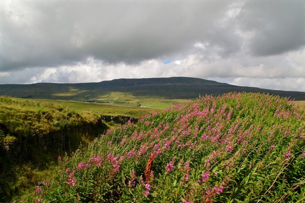
Making a living on this boggy land has always been extremely difficult. Shaded by Ingleborough, Simon Fell and Park Fell, there is little direct sunlight during winter. Hardy farmers still try to eke out a living here…

farmer

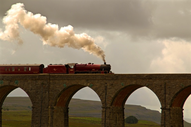
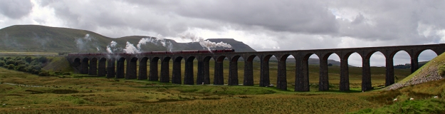
I took some fine photos of Chapel-le-Dale along the route, which I’ve already posted on Facebook and Twitter this week, showing Twisleton Scar, Whernside and Ribblehead Viaduct. Here’s a different one, looking down on the small settlement around the Chapel Inn.

chapdale

As Black Friday turned into Grey Saturday there were few photographic bargains to be had in the dales for me, but one of my neighbours, Mark Corner, emailed me this photo taken on Giggleswick Scar. Myths and legends surround these ‘fairy circles’, and here Mark’s lovely dog Oscar looks like a worthy king of the elves.

corner

Water way to go, cats, dogs and a dodgy chopper

ribweir

The value of natural flood plains in the Dales was highlighted this week as they calmed the flow of rivers swollen by the excessive rain. New lakes were created here in Ribblesdale and throughout the region, saving communities further down the valleys from severe flooding (apart from where housing and industrial development has been erroneously allowed). As well as poor planning decisions there are other problems along riverbanks which have been created by humans. One is the way some landowners have banked up river edges to preserve or increase grazing land. In times of flood these act as barriers, and instead of letting rivers spread naturally, they speed up flow causing problems elsewhere. Weirs, built in many cases to help power old mills and create mill ponds, can also have an adverse effect. I watched the weirs and Langcliffe and Settle this week and saw first hand what they do when the rivers are high and fast-flowing. These artificial barriers raise water levels behind then cause a huge hydraulic jump afterwards. This causes great turbulence and danger in the worst conditions as witnessed in my picture. I’m all for capturing a river’s power to create electricity through well-placed turbines but I wonder if weirs are really necessary today? Also, in low water weirs are a barrier to fish migration and promote the growth of algae.
dogturd

There’s a popular walk from Settle along Watery Lane, but it proved a bit too watery last Sunday. I did manage this photo, however, where it seems the local allotment holders or perhaps fellow walkers are fed up with coming across doggie-do. I’m not sure whether the luminous paint looks worse than the dog mess but it certainly gets the message across.
inglequarry

There was still plenty of water at the top of the dale on Monday as I took a stroll in the Ribblehead region and around Ingleborough Nature Reserve. Signs of industry don’t have to be depressing and can create some interesting views.

kilningle

whernquarry

While I was below  Ingleborough I came across the Coastguard Sikorsky S-92 helicopter which had got into difficulties the previous day. The Cave Rescue Organisation, based in Clapham, requested help from the Coastguard when they were called out to a walker suffering chest pains on Ingleborough. However, the chopper developed a fault and the rescue team had to help stop the multi-million pound contraption from toppling over. The human casualty was stretchered off the hill and taken by Landrover then ambulance to hospital. It took a further three days to rescue the rescue machine.
rescue

My cat knows that when I get the map out its food supplier is planning to leave the house and also turn off the heating, so he does his best at sabotage.
catmap

I was only away an couple of hours though, dropping over the Newby Head into Widdale and Wensleydale to visit the bonnie Cotter Falls. Great Knoutberry also looked grand from this angle.
cotterf

gtknout

The temperature dropped dramatically on Friday, especially on the moors above Malham. I’d planned to walk through the dry valley of Watlowes (pictured below) over to Malham Tarn but the wind was fierce and the conditions, well, nithering.
watlowetop

The drive back from Kirkby Malham to Settle was strange – on one side, looking towards Pendle, the change from cloud to sun was amazing; inspirational skies for the artists among us.

inspire

On the other side, as seen here with Ingleborough in the background and Warrendale Knotts in the foreground, was clear in bright blue sky.

ingwarren

Then the snow came yesterday so I headed back up Ribblesdale to do the Three Peaks (through photography from the car – I’m not that daft). The road up to Whernside was still pretty dodgy in the morning, especially where the sun hadn’t hit the road. The car told me the temperature was -1, goodness knows what it was like on top of those hills with the wind-chill.

whites

Sunsets, tarns, top views, trains and therapy

This week I took far more photos of trains than would normally be considered as healthy. Therapy has been suggested but in my defence it was the final week of the summer steam train season on the Settle-Carlisle line which runs close to my home. I’ve bunched a few of my favourites from Wednesday and Thursday at the foot of the blog. The helicopter, however, was not the form of transport I was expecting to see while waiting at Ribblehead Viaduct.
viacopter
After writing my previous blog on Sunday I walked up Ribblesdale to Stainforth and back to Langcliffe via the scar and Lower Winskill. There’d been thunderous storms the previous night and a new ‘tarn’ emerged at the foot of the scar. I suspect that eons ago there was once a tarn covering much more of this area as well as in many other parts of the dale.
newtarn
The calm after the storm brought about a fabulous sunset, and once again the camera went into overdrive. Here are a couple of my favourites looking west from Winskill Stones.
winsunsetsheepsunset
Wednesday saw me visit one of the old quarries on Ingleborough Nature Reserve where Nature is gradually taking over once again. This will one day be a super place for studying wildlife, plants and enjoying the landscape. There’s a well-designed seat which follows the contours of the background hills of Park Fell, Simon Fell and Ingleborough as well as portraying the underlying geology. There’s no doubting the major wind direction in this area – Whernside in the background.
windwhernquarryseatinrquarryquarryfall
I always know that summer is coming towards its end when the rowan berries add an orange tinge to the dale’s scenery. They sit well against the grey walls, barns and scars, contrasting perfectly against green pastures. This was taken on Thursday and shows Stainforth Scar.
orange
This week saw the publication of Dalesman’s Top 50 Yorkshire Views, as voted for by its readers. The county is spoilt for choice, of course, and we all have differing reasons for liking particular scenes. The number one view is that from Sutton Bank, looking across Lake Gormire, the York Plain and beyond. A cracking panorama which I suspect also came out tops because of the viewpoint being easily accessible. I prefer hillier landscapes with limestone scars, walls, barns, pastures: typical Yorkshire Dales scenes. Also, I like the element of surprise; being able to walk around a corner or reach the top of a hill where a whole ‘new’ view opens up before me and takes my breath away. I’ve seen so many of these around the Dales that I don’t think I could ever choose a favourite.  Check out the Dalesman website/buy the magazine – now on sale. www.dalesman.co.uk

As promised, more trains. Time to google ‘steam train therapy’.
trainpyg2traincloseviatrainwide

%d bloggers like this: