Dales highs and lows

treewall
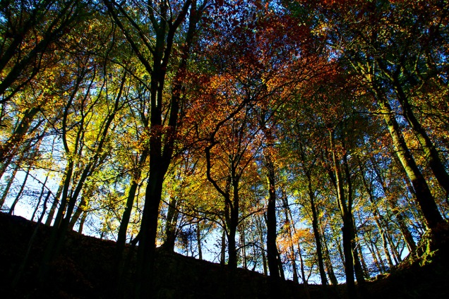
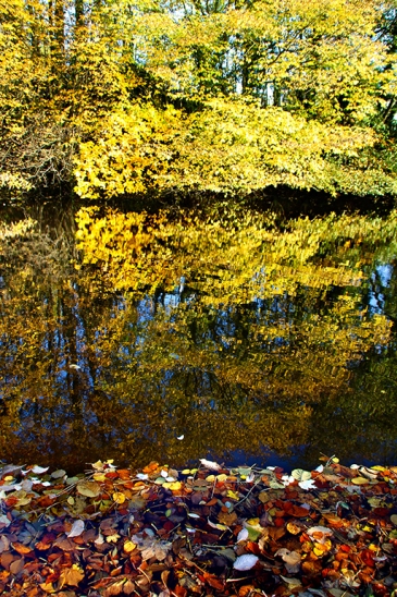
Excellent autumn light tempted me out into the Dales this week. I’ve been happy with the photographic results and, if my Twitter statistics are anything to go by, so have my followers. Then why do I feel a little down at the end of such a productive and enjoyable seven days?

Why? Because it’s becoming more apparent just how much the quality of our rural life is changing and how little the government seems to care about it.

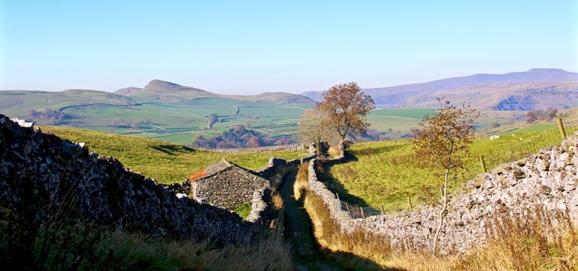
There’s a new kind of industrial revolution going on in the countryside and it’s increasingly noticeable around the edges of the Yorkshire Dales National Park.

Humans have always exploited the countryside. Mills developed around natural water power while lead and coal mines along with stone, slate and limestone quarries have been regular features in the Dales for centuries.

Driving around now I see an ever-increasing number of wind turbines. This week I stopped to view the massive solar power station at Gisburn, where 20,000 panels have been installed across three fields. Many more will follow.

Dales solarpanels
Thousands of solar panels at Gisburn

After bemoaning the fact that fracking had been allowed on the North York Moors a couple of months back, permission for fracking has now been granted down the road in Lancashire… despite the fact that the locals and the council didn’t want it to happen.

Further afield huge agricultural businesses are gobbling up small farms, turning millions of acres into featureless prairies or unnatural meat factories, ruining the countryside’s natural balance, destroying wildlife habitats and forever changing communities.

I live in a Dales village where the local primary school was closed a few years back – now we learn that the lovely school at Horton-in-Ribblesdale is seriously under threat. With it could go the life-blood and future of another rural community. Families will move out and the place will be filled with second-homeowners and holiday cottages. (Don’t get me wrong – those people are most welcome, but it is the community balance I worry about.)

Libraries and other local resources, including municipal parks, are also being abandoned by councils while funds for National Parks are being cut.

Yes, we must always look for solutions to problems concerning provision of food and power, but why must it be at the expense of our quality of life and the destruction of the things many of us hold so dear?

That’s ‘progress’ I’m told. Don’t fret youngsters, old dinosaurs like me will soon be extinct… unfortunately so will much of the countryside.

Talking of extinction, as I was heading home from Gisburn the other day I came across a farmer who was driving along a minor road, presumably next to his farm, in one of those golf-buggy-type-things. He pulled to the side of the road, grabbed his gun and fired it skywards. It was a tad disconcerting but something not to be too surprised at out in the countryside. I didn’t stop to find out what he was firing at, but I do hope it wasn’t a rare bird of prey – there have been too many reports of them being killed this year. That’s another sensitive rural subject concerning songbirds, farming and the hunting-shooting-fishing brigade – but enough ranting for one day… enjoy the photos.

Dales photos from this week

Dales countsheep
If you can’t sleep try counting the sheep in this photo – hundreds on the hillside in Ribblesdale
Dales bull
Cows – and a bull – gather at Winskill
Dales watlowes
Watlowes dry valley as the early mist was dispersing
Dales path
Autumn sunshine and path at Langcliffe
Dales stainscartint
Stainforth Scar showing some early autumn tints
Dales ingleborough
Evening light on Ingleborough
Dales attermire
Attermire in the afternoon
Dales trees-ingle
Ingleborough in the distance, seen from Langcliffe
Dales scaleber
Scaleber Force
Dales treesribble
Changing colours by the Ribble
Dales malhamtarn
More hints that autumn is upon us at Malham Tarn
Dales penyghent
I couldn’t go a week without a photo of Penyghent, could I?
Dales duck
A quiet moment on Langcliffe mill pond

Fire-breathing monsters in Ribblesdale

ribblesdale - coverdale

I love maps. From where I’m typing this in my Ribblesdale cottage I can see about 20 of them, balancing precariously on a shelf. I have an 1841 tithe map of Langcliffe framed and hung on a wall. I often read maps instead of a books; I’m forever scouring them for new features or to compile fresh walks. There’s probably a polite name for someone with such an obsession. But I wonder if the end of the large folded paper map is upon us. I hope not. This week the OS were trying to flog a new deal for online mapping for smartphones. You can get unlimited mapping plus a host of other clever do-dahs for an annual fee. I can’t afford a smartphone or indeed yet another annual fee, so when I’m out in the Dales I’ll continue to bumble along in my quaint old-fashioned way – so I hope they are kept up to date. One day last summer I was out on the moors above Dent, sitting on a rock, eating a sandwich and reading a map. A couple of hikers approached me and asked for guidance because their gizmo had ‘died’. Smug, is how I would describe my mood that day. They were foolish not to take a proper map – no batteries required.

Ribblesdale mayhem?

ribblesdale - train

In last week’s blog I went off on one about HS2 and how the high-speed railway will destroy much countryside just to cut a few minutes off a journey. I compared my anger to that of people of Ribblesdale when the Settle-Carlisle line was cut through the dale. Out of interest (it was raining again) I pored over a pre-railway OS map of the route – published in 1842. As much as I admire the engineering feat needed to take the railway through some very tricky parts of Ribblesdale, its construction must have caused mayhem. And let’s face it, as much as many people enjoy seeing the big old steam locos chugging up and down the line today, residents at the time would have dreaded the great fire-breathing monsters spewing out filthy smoke and making a noise like a herd of rampaging elephants. The incline from Settle to Ribblehead passes over some tough terrain – everything from solid rock to boggy marshes. Much of the work was done manually as the line inched up Ribblesdale; so hats off to the poorly-paid workers whose section is still providing services.
The same can’t be said about the route further north, near Appleby, where ground saturated by unprecedented rainfall has become unstable. The line could be closed for several months for repairs. I hope this doesn’t put passengers off coming to Ribblesdale or using the line between Leeds and Appleby. http://www.settle-carlisle.co.uk
I hope too that there is a good service available by April 29 when the Tour o’ Yorkshire (I’m refusing to use the ‘de’ – what’s it got to do with the French?) comes to the area. There will be a public meeting at Victoria Hall, Settle, on Monday Feb 29 (6pm) to discuss local plans.

ribblesdale - snowdrops

Lovely to see snowdrops appearing around the village once again. Their brief show is said to herald the arrival of spring. I suspect as usual in these parts that their appearance is premature.

ribblesdale - watlowes

I snatched an hour or so out on the fells above Malham one bright breezy day this week. Hardly a soul to be seen as I wandered along the Pennine Way between Watlowes valley and the Tarn, normally quite a busy trail at the weekend. Note to self: do this walk in the morning so as not to get the dark shadow on the west slope of Watlowes. The Tarn took on a deep dark blue hue when viewed from a little knoll just off the path.

ribblesdale - malham tarn

Mind clearing

When my head is full of all sorts of daft stuff I’ll often drive the car over to Halton Gill on the Stainforth road to try clear my mind. There are only half a dozen farms from one end to t’ other along the seven miles or so. The landscape and views are breathtaking. I get out of the car, mooch about, find a new spot from which to take a photo, or as on Friday sit and stare at two daft beggars cycling up that incredibly steep hill from Halton Gill.

ribblesdale - haltongill
The light changed rapidly as the clouds scuttled across lovely Littondale. For a few seconds the tiny hamlet was bathed in sunshine. Behind it, the domineering moors switched from moody browns to inviting orange, while the tops kept on their dreary, misty hats.
The smaller, less populated dales have always appealed to me – Kingsdale, Coverdale, Raydale, to name but three – and they’re all firmly on my to-do-again list in spring. The top picture in the blog was taken from Coverdale, looking back down the valley towards Wharfedale. Here’s one looking across Kingsdale.

Ribblesdale - kingsdale

Well, it’s St Valentine’s Day again and in true Yorkshire bloke fashion I say ‘thank goodness I don’t have anyone to waste mi brass on’. I expect all my cards and gifts will arrive via a fleet of home delivery vans tomorrow, it being Sunday today.

Water way to go, cats, dogs and a dodgy chopper

ribweir

The value of natural flood plains in the Dales was highlighted this week as they calmed the flow of rivers swollen by the excessive rain. New lakes were created here in Ribblesdale and throughout the region, saving communities further down the valleys from severe flooding (apart from where housing and industrial development has been erroneously allowed). As well as poor planning decisions there are other problems along riverbanks which have been created by humans. One is the way some landowners have banked up river edges to preserve or increase grazing land. In times of flood these act as barriers, and instead of letting rivers spread naturally, they speed up flow causing problems elsewhere. Weirs, built in many cases to help power old mills and create mill ponds, can also have an adverse effect. I watched the weirs and Langcliffe and Settle this week and saw first hand what they do when the rivers are high and fast-flowing. These artificial barriers raise water levels behind then cause a huge hydraulic jump afterwards. This causes great turbulence and danger in the worst conditions as witnessed in my picture. I’m all for capturing a river’s power to create electricity through well-placed turbines but I wonder if weirs are really necessary today? Also, in low water weirs are a barrier to fish migration and promote the growth of algae.
dogturd

There’s a popular walk from Settle along Watery Lane, but it proved a bit too watery last Sunday. I did manage this photo, however, where it seems the local allotment holders or perhaps fellow walkers are fed up with coming across doggie-do. I’m not sure whether the luminous paint looks worse than the dog mess but it certainly gets the message across.
inglequarry

There was still plenty of water at the top of the dale on Monday as I took a stroll in the Ribblehead region and around Ingleborough Nature Reserve. Signs of industry don’t have to be depressing and can create some interesting views.

kilningle

whernquarry

While I was below  Ingleborough I came across the Coastguard Sikorsky S-92 helicopter which had got into difficulties the previous day. The Cave Rescue Organisation, based in Clapham, requested help from the Coastguard when they were called out to a walker suffering chest pains on Ingleborough. However, the chopper developed a fault and the rescue team had to help stop the multi-million pound contraption from toppling over. The human casualty was stretchered off the hill and taken by Landrover then ambulance to hospital. It took a further three days to rescue the rescue machine.
rescue

My cat knows that when I get the map out its food supplier is planning to leave the house and also turn off the heating, so he does his best at sabotage.
catmap

I was only away an couple of hours though, dropping over the Newby Head into Widdale and Wensleydale to visit the bonnie Cotter Falls. Great Knoutberry also looked grand from this angle.
cotterf

gtknout

The temperature dropped dramatically on Friday, especially on the moors above Malham. I’d planned to walk through the dry valley of Watlowes (pictured below) over to Malham Tarn but the wind was fierce and the conditions, well, nithering.
watlowetop

The drive back from Kirkby Malham to Settle was strange – on one side, looking towards Pendle, the change from cloud to sun was amazing; inspirational skies for the artists among us.

inspire

On the other side, as seen here with Ingleborough in the background and Warrendale Knotts in the foreground, was clear in bright blue sky.

ingwarren

Then the snow came yesterday so I headed back up Ribblesdale to do the Three Peaks (through photography from the car – I’m not that daft). The road up to Whernside was still pretty dodgy in the morning, especially where the sun hadn’t hit the road. The car told me the temperature was -1, goodness knows what it was like on top of those hills with the wind-chill.

whites

Falls, falling, fells and the fallen

DSC_0077.JPG

There’s a splendid website which I regularly visit called grough.co.uk which offers all sorts of news and views for walkers, visitors and residents of the Dales, Lakes and beyond. I read a report on there on Tuesday of a walker being rescued from Watlowes dry valley above Malham (pictured). The Clapham-based Cave Rescue Organisation came to the walker’s aid. It was the team’s 72nd rescue of the year. What a great job done by them and the other volunteer rescue teams, such as uwfra.org.uk.
catfallsuprightIt is so easy at this time of year to slip and slide on the fells. I nearly came a cropper myself, slipping on damp limestone while heading down the steep bank to Catrigg Force on Monday. All I was bothered about was my camera. We both emerged unscathed. I got a few photos of the water falls but I’ve not yet captured my ideal shot of this place. There’s usually a lot of ‘clutter’ in the way, but with leaves now dropping rapidly more can be seen of the main falls. Also, there’s such a contrast between the bottom half and the top half of the scene that getting the exposure right is difficult. Perhaps some experts can advise.

The bright blue sky seen through the canopy at Catrigg was almost the last I saw of it this week.

treescatrigg

The track up from Stainforth to Catrigg and on to Winskill seems to get steeper every time I tackle it but the view back down between the walls, looking over to Smearsett Scar and Ingleborough, provides a perfect excuse to stop.
stainlane

Tuesday’s stroll from Langcliffe to Settle via Victoria Cave and Warrendale Knotts was a strange affair. I moved from bright sunshine into thick fog several times. It’s a good job I know the route well – it would have been so easy to have strayed off course. Here’s one of the bright moments:

warrenmist

The landscape’s outline along this part of Stockdale sometimes reminds me of the wild west as seen in old cowboy films. So I couldn’t believe it when I saw heading towards me a herd of cattle being driven down from the hills by some farmhands. Ye-ah.

cattledrive

I chap momentarily mistook me for Mike Harding in Settle the other day; on top of this, someone else mentioned our similarities on Twitter. I wouldn’t mind but he’s even shorter than me and is also about 10 years older.  Either I’m looking older than my age or he appears youthful… let’s go with the latter. Perhaps I can get away with a few free pints around Settle? As long as they don’t ask me to sing Rochdale Cowboy or play the banjo. If you’re a fan of folk and traditional music I highly recommend Mike’s podcast which can be downloaded (for nowt) from mikehardingfolkshow.com every Sunday. Perhaps you can listen to it while reading this blog and imagine we’re the same person.
pondleaves
Even though I am ancient I still enjoy kicking my way through the fallen leaves as I’m walking down country lanes. The leaves offer an opportunity for some creative work with the camera – not that it’s my normal style, but I liked the colours and patterns of this shot across Langcliffe Mill Pond taken last Sunday.

Unfortunately, another engagement means I miss the Remembrance service at the village memorial today when the names of Langcliffe’s fallen are read out.

poppybw

%d bloggers like this: