Hungry birds, hairy pensioners, headless corpses and a chuffing Scotsman

Langcliffe
The Yorkshire Dales village of Langcliffe sitting beneath limestone scars in Ribblesdale.

Since my last blog, my hair has grown a lot and I’ve baked two lots of bread and a batch of scones. Even the birds turned their beaks up at my first loaf. The second one was a little more edible, but considering the length of time it took me to prepare and bake, and the carnage left to clean and tidy up afterward, I won’t be attempting a third loaf. The scones were edible if a little deflated. I love scones but even I got fed up with them after the tenth one. No wonder I’m piling on weight. I tried to convince myself this was because of the amount of hair on my head, which is now as long as it was during my Hippy days of the 1970s.
Oh, and during the good weather I did manage some splendid walks from home, so I do have a few new photos to show. The top photo was taken on my way up Giggleswick Scar on the opposite side of the dale.

Settle
Settle seen from Giggleswick Quarry.
quarry
Giggleswick Quarry. Workings stopped here 12 years ago and the site was sold in 2019. I have no news yet of developments. In the distance is Pendle Hill.

Before the lockdown we used to curse about the time we had to wait at the checkouts at our local supermarket, now we bleat at having to queue outside waiting to get in. A former neighbour spotted me in the queue the other day and decided we should carry out a conversation despite us being four metres apart. The person between us appeared distinctly awkward but definitely unwilling to give up her position to allow the conversation to continue in a slightly less public manner.

Winskill view
I can never resist capturing this scene when I’m up the road from my home. View over Winskill to Ingleborough.

Most conversations now seem to take place digitally. However, I’ve had a break from social media recently, just taking occasional peeks at my accounts but not back-tracking. So if anyone has been expecting a response from me, I apologise – you’ll have to message me directly, email or phone Why not write me a letter? A postcard would be nice.

Ribblesdale

In the shade of the hawthorn tree pictured above, which looks splendid in its spring clothes, is a simple plank bench. There’s probably been a seat here for many years, sited on an old track up the hill from Langcliffe to Winskill. It’s a handy resting place before tackling the path’s steep section, and gives you a chance to sit and admire a fabulous view up Ribblesdale (pic below shows part of what’s on offer).

Ribblesdale

If you’re still stuck at home you might have time to read this tale from the Dales, one of many I’ve picked up during my years traveling the region and working as editor of Dalesman.

Nidderdale
The view across Scar House reservoir towards Dead Man’s Hill

There are no modern roads between Horsehouse in Coverdale and Middlesmoor in Nidderdale – a distance of just over five miles as the crow flies. The shortest route by car is nearer 27 miles. Between the two dales is a mighty ridge which for much of its length rises between 1,600-2,000ft high and is bleak uncultivated moorland. It generally marks the border of the south-eastern end of the Yorkshire Dales National Park.
Today, on the Nidderdale side of the ridge lie Angram and Scar House reservoirs holding vast amounts of water to be used by the citizens of Bradford. For hundreds of years before this top end of the valley was dammed in the 1920s, animal dealers crossed this barren barrier on their way from the north, as far as Scotland, to trade in the West Riding.
There is still an ancient track between Horsehouse and Middlesmoor, settlements that were handy stopping-off points for the jaggers, as the packmen were called. Midway between the two places, just on the Nidderdale side, is Lodge. Now a farm, it was in the early 1700s a remote inn run by a mother and her daughter.
The inn would have been a welcome sight for the men after tackling the long steep hill from Coverdale, battling against the worst Dales weather and the rough terrain. Unfortunately for some of those weary travelers, their journeys – and their lives – would end in this miserable place in mysterious and macabre circumstances.
There are a few versions of the story of what happened to the poor souls, some perhaps being over-embellished during the last 300 years. Several of the packmen became well known after traveling the same route for many years. So locals started asking questions when some of them failed to turn up. It became more apparent that something was amiss when the wives of three Scottish packmen headed south to find out why their husbands had not returned home.
They discovered that the men had been seen at Horsehouse but not in Middlesmoor. It had also been noted that the Lodge innkeepers suddenly seemed more prosperous, and that farmers in the area were using Scottish ponies, and that their wives were wearing Paisley shawls, having been sold to them by the ladies of the inn.
Following a search of the area (now known as Dead Man’s Hill) near the inn, three headless bodies were found buried in shallow graves. The story goes that the two women got the men drunk and cut off their heads. Some say the bodies were discovered by travelers only when they spotted the packmen’s abandoned sheepdog digging at the burial site.
What happened to the culprits is not clear. One version says they were taken to Pateley Bridge where they were tried and hung. Another claims that the pair were found to be witches who turned to stone on the hills. Known as Jenny Twigg and daughter Tib (below), the pair of stone sentinels stand isolated, overlooking the bleak moorland of upper Nidderdale.

The lambs and sheep have kept me amused on my local walks…

sheep
Does my bum look big in this?

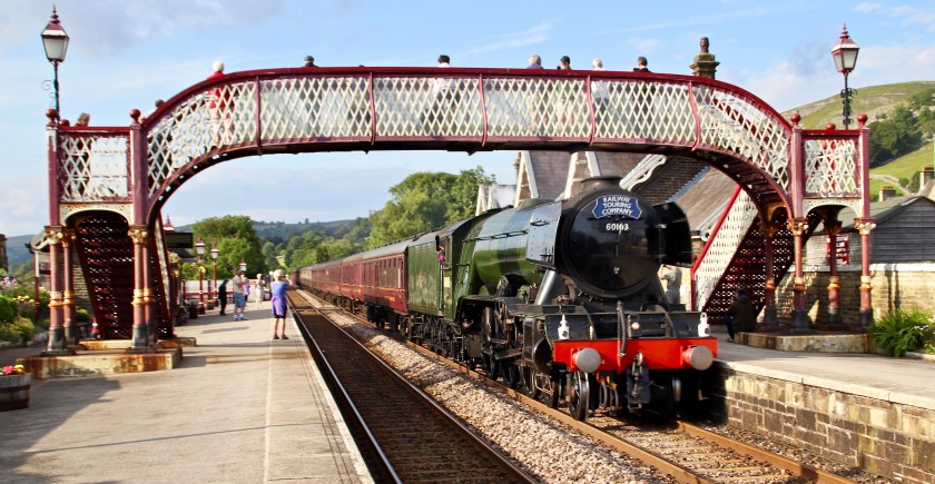
Sadly no trains yet so here’s one from last year at Settle station.

Flying Scotsman
Flying Scotsman on the Settle-Carlisle line.

Restricted Dales travel – even for royals like me

Well, that was a weird month, wasn’t it? I can’t come on here this time and brag about all the wonderful places I’ve visited and photographed recently around the Yorkshire Dales. Where I live is great, and I count my blessings that I don’t live in a city, but I still have the desire to get out and see, listen to, smell and feel different places.

Put a compass on a map and draw a radius representing an hour’s return walk from your house, and you’ll soon realise the restrictions we’ve been under. (Younger readers: maps and compasses are old fashioned tools, look them up in a book – ‘What’s a book, Granddad?’ – sorry, I mean visit Wikipedia.)

The bank of ramsons (wild garlic) beside the Ribble in Langcliffe gets more impressive every year. I seem to remember there being many more bluebells in this little wood in the past, so perhaps the ramsons have pushed them out.

Fortunately, the River Ribble is within permitted reach for me, although it has been very low recently, and last week it resembled an abandoned quarry. In fact, I watched someone quite easily walk across the rocky bed to the other bank without getting their feet wet. I thought it was taking social distancing a bit too far, I was about 100 yards away.

I can just about manage a walk to Stainforth and back within the hour, depending on the number of camera halts needed. A same-day Settle return (with pensioner pass) is easily within reach. A trek up to Winskill Stones tests my stamina. My lack of exercise (and extra pounds) is starting to tell.

lambs
Exhausting, this lockdown malarky.

On the upside, lockdown has given me more time to investigate my family tree, something I started doing some 40+ years ago and which I’ve flitted in and out of ever since. A while back I discovered that my lot linked into a knighted Yorkshire family. During my latest investigations, I was able to follow this line even further, and it took me way back to the ancient kings of the north. The tree even ties into that of the current royal family. It seems that the Queen’s 28xgreat-grandparents were also my 31xgreat-grandparents and that we’re both related to Alfred the Great who lived in the second half of the ninth century. This is a satisfying discovery but shouldn’t be too surprising apparently, as it is thought that millions of today’s Brits are related in some way to our ancient royals. Finding the path back to them is the hard bit. I shan’t be waving serenely from my battered Polo to any passing subjects just yet.

St John’s, Langcliffe.

I’ve been flicking through hundreds of old photos in my archive so that I can post a pic a day on Twitter and Facebook during the shutdown. My Daily Dales postings have helped me pass the time away. My thanks go to those who up to yesterday had clocked up nearly 90k visits on Twitter in the last 28 days, and also to my faithful family and friends on Facebook who are reacting well, too.

Hunter’s Stone, Coverdale.

While rooting through my collection, I came across the above photo taken in 2013. The old stone sits lonely and exposed at the head of Coverdale just before Park Rash, the steep winding road that links Wharfedale with Coverdale, descends into Kettlewell. The tiny road was nothing but a track until the 1950s when it was first coated in tar, but it had been a monks’ way before that, and also a drovers’ road. It is believed that Iron Age people worked their way up here too, as evidence of extensive fortifications can be found (Ta Dike) across the brow of the hill. Back to the old stone, which is called Hunter’s Stone. It contains a small cross and was originally erected to guide monks traveling from Coverham Abbey to Kettlewell where they held land and took sheep to market. Local legend has it that every time the clock struck twelve at Hunter’s Hall, a few miles down the dale, the stone turned around. Hunter’s Hall is now called Coverhead Farm. Just a little bit further down Coverdale is West Close, which I’m told was once called Sod Hall. Shame they changed the name; it seems quite appropriate for today.

Lovers’ Lane, Langcliffe?

This weekend we rightly recognise the sacrifice made on our behalf by those who lost their lives in WW2. But I admit to feeling a little uncomfortable when people talk too much about ‘celebrations’ and ‘parties’ for VE Day. Remembrance and commemoration are more appropriate when thinking about humanity’s biggest catastrophe. Worldwide, 60 million people died during the war – take that figure in; it’s the equivalent of the whole population of the UK.

dandelion
Help our pollinators.

Dandelions are such useful plants for our pollinators – and therefore humans – so we shouldn’t kill them while in flower. The green in the village hadn’t been cut for some time and was covered in daisies, dandelions and clover: perhaps not too good for playing football but excellent for bees and butterflies… and it looked good, too – but perhaps only in mind, as the green has now been shorn and the bees and butterflies must now find their nectar elsewhere.

Fire-breathing monsters in Ribblesdale

ribblesdale - coverdale

I love maps. From where I’m typing this in my Ribblesdale cottage I can see about 20 of them, balancing precariously on a shelf. I have an 1841 tithe map of Langcliffe framed and hung on a wall. I often read maps instead of a books; I’m forever scouring them for new features or to compile fresh walks. There’s probably a polite name for someone with such an obsession. But I wonder if the end of the large folded paper map is upon us. I hope not. This week the OS were trying to flog a new deal for online mapping for smartphones. You can get unlimited mapping plus a host of other clever do-dahs for an annual fee. I can’t afford a smartphone or indeed yet another annual fee, so when I’m out in the Dales I’ll continue to bumble along in my quaint old-fashioned way – so I hope they are kept up to date. One day last summer I was out on the moors above Dent, sitting on a rock, eating a sandwich and reading a map. A couple of hikers approached me and asked for guidance because their gizmo had ‘died’. Smug, is how I would describe my mood that day. They were foolish not to take a proper map – no batteries required.

Ribblesdale mayhem?

ribblesdale - train

In last week’s blog I went off on one about HS2 and how the high-speed railway will destroy much countryside just to cut a few minutes off a journey. I compared my anger to that of people of Ribblesdale when the Settle-Carlisle line was cut through the dale. Out of interest (it was raining again) I pored over a pre-railway OS map of the route – published in 1842. As much as I admire the engineering feat needed to take the railway through some very tricky parts of Ribblesdale, its construction must have caused mayhem. And let’s face it, as much as many people enjoy seeing the big old steam locos chugging up and down the line today, residents at the time would have dreaded the great fire-breathing monsters spewing out filthy smoke and making a noise like a herd of rampaging elephants. The incline from Settle to Ribblehead passes over some tough terrain – everything from solid rock to boggy marshes. Much of the work was done manually as the line inched up Ribblesdale; so hats off to the poorly-paid workers whose section is still providing services.
The same can’t be said about the route further north, near Appleby, where ground saturated by unprecedented rainfall has become unstable. The line could be closed for several months for repairs. I hope this doesn’t put passengers off coming to Ribblesdale or using the line between Leeds and Appleby. http://www.settle-carlisle.co.uk
I hope too that there is a good service available by April 29 when the Tour o’ Yorkshire (I’m refusing to use the ‘de’ – what’s it got to do with the French?) comes to the area. There will be a public meeting at Victoria Hall, Settle, on Monday Feb 29 (6pm) to discuss local plans.

ribblesdale - snowdrops

Lovely to see snowdrops appearing around the village once again. Their brief show is said to herald the arrival of spring. I suspect as usual in these parts that their appearance is premature.

ribblesdale - watlowes

I snatched an hour or so out on the fells above Malham one bright breezy day this week. Hardly a soul to be seen as I wandered along the Pennine Way between Watlowes valley and the Tarn, normally quite a busy trail at the weekend. Note to self: do this walk in the morning so as not to get the dark shadow on the west slope of Watlowes. The Tarn took on a deep dark blue hue when viewed from a little knoll just off the path.

ribblesdale - malham tarn

Mind clearing

When my head is full of all sorts of daft stuff I’ll often drive the car over to Halton Gill on the Stainforth road to try clear my mind. There are only half a dozen farms from one end to t’ other along the seven miles or so. The landscape and views are breathtaking. I get out of the car, mooch about, find a new spot from which to take a photo, or as on Friday sit and stare at two daft beggars cycling up that incredibly steep hill from Halton Gill.

ribblesdale - haltongill
The light changed rapidly as the clouds scuttled across lovely Littondale. For a few seconds the tiny hamlet was bathed in sunshine. Behind it, the domineering moors switched from moody browns to inviting orange, while the tops kept on their dreary, misty hats.
The smaller, less populated dales have always appealed to me – Kingsdale, Coverdale, Raydale, to name but three – and they’re all firmly on my to-do-again list in spring. The top picture in the blog was taken from Coverdale, looking back down the valley towards Wharfedale. Here’s one looking across Kingsdale.

Ribblesdale - kingsdale

Well, it’s St Valentine’s Day again and in true Yorkshire bloke fashion I say ‘thank goodness I don’t have anyone to waste mi brass on’. I expect all my cards and gifts will arrive via a fleet of home delivery vans tomorrow, it being Sunday today.

%d bloggers like this: