Let me take you on a little drive around the western Dales. On the one clear day this week I drove along the back roads of Wenningdale from Settle to the Great Stone of Fourstones (pictured below), above Bentham, with the hope of taking some long-distance shots of the Three Peaks and perhaps even the southern fells of the Lake District. Although there was plenty of blue sky above, there wasn’t the clarity. I did manage these photos of the Dales and beyond:
Unusual shot up the spine of Whernside with Ingleton in the foreground; below, Ingleborough seen from Great Stone.
Not the clearest of shots but you can make out the snow-capped tops of the South Lakeland Fells.
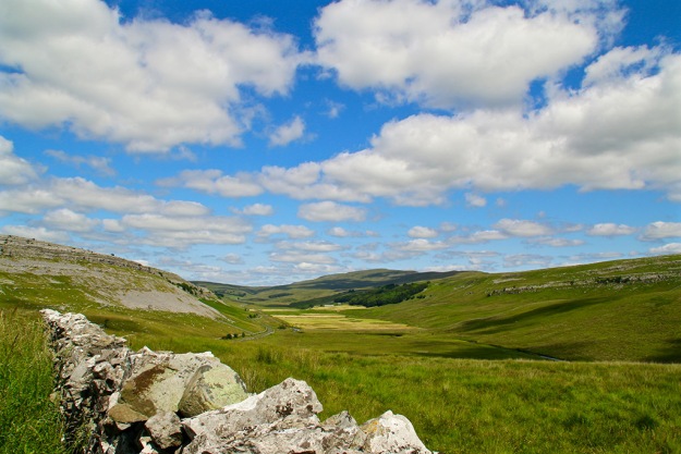
From that amazing boulder I drove on to Thornton-in-Lonsdale and through lonely Kingsdale (top photo in blog). Apart from a gang of cavers trooping up to Yordas I didn’t see another soul for miles. Driving the steep single track road towards Dent always makes the heart beat a little faster. For most of the way you’re praying there’s nothing coming in the other direction; that the mist doesn’t come down; or in my case hoping that gawping too long at the view doesn’t mean I miss a tight bend in the road.
View back down Kingsdale from a gate stop.
I double-check my handbrake every time I get out of the car to open and shut the gates along here. A little stroll up the old quarry road towards High Pike is always worthwhile. The views down Deepdale, Dentdale, towards the Howgills and north-western dales are rewarding.
There is a magical little waterfall as you descend into Deepdale – it’s unnamed on the OS map.
Instead of continuing to Dent I took the back-road to Cowgill – apparently I couldn’t have done this the previous day because of flooding. Every time I drive along this lane, passing Whernside Manor, I remember the creepy stories I’ve read of the mansion’s past. Tales of slavery and ghosts, and people being chained up in the cellars can be found on the internet if you’re interested. Believe what you want, but when one site describes Whernside hill as being part of the Howgills, you do start to question the depth of research.
After more stops for photos of the river Dee (below) and the old buildings at Stone House (above), where Dent marble was once produced, it was under the Settle-Carlisle railway at Dent Head Viaduct and on to Ribblehead, before turning down to Settle under the familiar gaze of Penyghent.
I pulled off the Ingleton-Hawes road for this moody shot of Ingleborough.
What a difference a Dales day makes
The trip was a contrast to the previous day when I’d driven on t’other side of Penyghent towards Halton Gill from Stainforth. Typical of this part of the dales, water was pouring off the sodden fells, filling the becks and waterfalls which feed Penyghent Beck before splashing down into Littondale. I was wet but the noise and the freshness were exhilarating:
Fountains FellPenyghent
The clouds opened up briefly to reveal a surprising vivid sunset last night. I didn’t have time to pop up to higher ground but these from around the village show the intensity of the colours – no filters used here.
I heard a TV reporter, on probably her first visit to the area, describe Settle as ‘a sleepy little town in the Dales’. She was covering the Tour de Yorkshire on the day the media and cycling circuses (is that the plural?) descended on my part of Ribblesdale. ‘Sleepy’ Settle had woken up extremely early to the prospect of a media mosh pit in the market place and a lycra-clad army of warriors on wheels whooshing through the tiny main street, clearly breaking the 20mph speed limit while dozens of police just stood and watched. Over many weeks, various organisations, businesses, schools and individuals had been trimming the town for its 15 minutes of fame (and hopefully a much longer legacy) – and what a fantastic job they did. The Hollywood lettering on Castleberg Rock, the shop decorations and Giggleswick school’s brilliant landscape art being just a few of the worthy efforts. If you haven’t seen the Gigg art visit: https://www.youtube.com/watch?v=7QOjxiXcFzg&sns=fb
I trudged up Buckhaw Brow to watch the cyclists flash by. I initially thought it was cruel to start the sprint at the top of a 12 per cent climb, but hey, these guys are masochists anyway so they probably got some kind of perverted pleasure from the pain. Frenchman Anthony Turgis (Cofidis) – pictured – was first to the sprint start near the top of Buckhaw Brow but he ended the race in Settle in 29th position – serves him right for showing off up t’ hill.
Of all the colourful action and crowd photos I managed to capture, my favourite photo of the day was this shot of former Tour de France stage winner Brian Robinson. The 84-year-old from Mirfield stopped (in a car entourage, not on a bike) at the start of the sprint to sign autographs and say hello to the hardy souls enduring the cold at this exposed spot. His delight and that of an admiring young fan is clear to see.
Walking back to Langcliffe from Buckhaw Brow via Giggleswick Scar I could see clearly how much snow remained on the high hills and I wondered how that would affect those taking part in the annual Three Peaks race the following day (yeah, really sleepy this area intit?). As it happened, around 700 athletes completed the course with Marc Lauenstein finishing at Horton in Ribblesdale in 2hr 48min 58sec – just three minutes outside the course record despite the freezing conditions. Mad as a box of frogs, the lot of them.
Ribblesdale erosion
The already eroded course will have suffered greatly from yesterday’s pounding. I know the race organisers and others help a lot with path maintenance around Ribblesdale and the Three Peaks, and we all need to play our part. Some people could find irony in the fact that the Yorkshire Dales National Park Authority (YDNPA) is organising a walk to raise money for vital work needed to care for paths being eroded by hikers. I’m sure the walk will do more good than harm! The YDNP is teaming up with the Heart Foundation charity for ‘A Day in the Dales’ centred on the Three Peaks. A selection of sponsored walks are being arranged for June 18 with all money raised being split between the charity and the Three Peaks Project. For more information about the events and entry forms visit http://heartresearch.org.uk/3peaks
Weatherwise we’ve had all four seasons during the week in the Dales – although we could perhaps have done with some thunder and lightning to complete a full set. On Tuesday I was driving down Ribblesdale and got a shot of Drybeck Farm and Penyghent (first pic in blog). Then around 7.45pm I just had to stop and capture fabulous late sunlight on St Peter’s, Stainforth. This Gothic revival church, consecrated in 1842, might not have the ancient history of neighbouring churches but certainly has a presence.
The snowfall got me looking back through my photo archive to see what was happening around this time in previous years. Last year I was enjoying the sun in Littondale where trees were budding well.
In 2014, April 29, notice the blossom and greenery at Dent.
The previous year I walked in T-shirt and shorts beside the Ribble from Helwith Bridge to Horton.
Dent days
Mention of Dent reminds me that last week I had to leave out pictures of a steady stroll I had around Cowgill at the top end of Dentdale. The stream sometimes disappears out of sight here and you can walk up the river bed; at other times water rushes down from the surrounding hills to create a spectacular sight. The steep hillsides along with white-painted cottages give the area a Lake District feel. (Stupid auto correct keeps changing Dentdale to Dental and Cowgill to Cowgirl so apologies if I’ve missed any.)
The former newsman in me said I ought to go find some dramatic flood shots last week, but then I thought that would only be adding to the misery of the situation. Flooded fields, gushing rivers and waterfalls are often witnessed here in Ribblesdale but further down the valleys, as all that water looks for a way back to the sea, many homes, businesses and lives can be ruined as a consequence.
In Nature, every action causes a reaction. When us humans mess with Nature, be it through greed or naivety, we generally cause mayhem somewhere down the line. Hopefully, a lesson is being learned about what causes flooding besides awful weather: the value of flood plains and why they shouldn’t be built upon; the erroneous river-banking to increase landownership; the cutting down of trees which absorb water; the bad management of moorland; the slashing of funds needed for proper river dredging, etc. Our obsession with cars doesn’t help – we build roads without adequate consideration for natural water flow, create enormous car parks; remove gardens so cars can be parked… the list goes on.
In 2012 I wrote a Diary piece in Dalesman following some more dreadful flooding in Hebden Bridge – here’s an extract: “ … many residents are partly blaming the management of the nearby Walshaw Moor where it is claimed that excessive burning of the blanket bog has been taking place. The estate owners, [headed by Boundary Mills businessman Richard Bannister] have also created new tracks through the 6,000ha estate which has increased the flow of water down the hillside. Sphagnum moss, Nature’s ‘sponge’ which slows the water coming off the moor, is rapidly disappearing as the estate owners try to create a habitat for red grouse which are then shot. “The management of this estate has caused Natural England to raise serious concerns in recent years. However, in March, without a clear explanation, Natural England reached an agreement with the landowners over the estate management and dropped legal proceedings, including a prosecution on 43 grounds of alleged damage. “Residents have set up a Ban the Burn campaign and are asking for support. They say: “We are aware that this is not just a local issue and it is not just about flooding. Sphagnum mosses are the main peat forming species providing vital carbon sequestration and carbon storage, but damaged UK peatlands currently release almost 3.7 million tonnes of CO2, equivalent per year of more than all the households in Edinburgh, Cardiff and Leeds combined.”
Three years on the battle to see sense continues, and the unfortunate residents of Calderdale are still suffering. This isn’t just me having a go at rich folk again. We could all do more… by protesting against stupidity and greed and offering practical help: simple things like helping rid your local beck of rubbish, keeping drains clear of leaves and other debris, making sure your garden has grass, trees and plants and not just covered with impervious Tarmac or decking. Rant over.
The promise of blue sky tempted me out on Tuesday. Mist hung around the tops of the Three Peaks (Penyghent below) as I drove through Ribblesdale to Dentdale. The simple old road bridge over the beck is dwarfed by the viaduct on the Settle-Carlisle line at Cowgill. I turned up the steep, Third-World-road between Dent and Garsdale railway stations where the views in all directions are wonderful. I couldn’t imagine making a living on these wild, boggy moors – it seems some have tried and failed. Returning home via Appersett, which had been cut off by flooding the previous day, a patch of blue sky briefly lit up Stags Fell as though nothing untoward had happened over recent times.
A couple of centuries ago, the main road from Settle to the west went through Giggleswick, Lawkland and on towards Austwick and Clapham. These places are now all bypassed by bigger, faster roads. The old lanes and off-shoots provide a pleasant drive or walk in lovely countryside completely missed by the majority of motorists to this part of the Dales. Those who travelled the ancient route by horse and cart centuries ago would have probably stood mouth agape at the sight of the mainly Elizabethan Lawkland Hall (a private residence with a fascinating history). Visit www.hha.org.uk/Property/568/Lawkland-Hall
My route was only just clear of water problems as I carried on through Austwick (pictured), and on to the hamlet of Wharfe (first photo in blog). The road back to Ribblesdale via Helwith Bridge was impassable the previous day because of flooding.
The following day I ascended – on foot – the steep slope from my house to Winskill Stones. It’s only a mile, but after eating and drinking excessively since my last trip up that hill I needed several ‘photo halts’. The light in the north-west was weird, probably something to do with incoming storm, while above and behind me was a bright blue sky.
A classic Winskill shot beckoned as that gallant tree, seemingly sprouting impossibly from the limestone, and Lower Farm standing out like a beacon set the scene.
Descending back down the side of Stainforth Scar looking towards Settle I saw that the mysterious vanishing tarn was back again. Geological features, ancient field patterns, the rolling Ribble and distant Langcliffe Mill show the development of this area.
Impressive as they were, I felt a tad miffed watching London’s extravagant fireworks on New Year’s Eve. Knocking on £2m spent on 11 minutes, during which time half of London’s population stood with camera phones pointing towards the sky, taking blurry pictures that will end up looking like the remnants of a three-year-old’s birthday party spread. £2m can be raised for the capital’s hedonistic event but ask for brass for London’s homeless or the North’s flood victims and people look the other way. Call me a party-pooper if you want, but I’m sure we used to enjoy NYE just as much before all this excess.
Ribblesdale photos
For my final photo round-up of the year I’ve chosen from pictures taken between September and November inclusive. I’ve not included December as most can be viewed in recent posts. Have a happy new year and thanks for dropping by.
Why do some drivers hurtle through the Dales like they’re on an audition for a Top Gear presenter slot? I was forced off a narrow lane by two idiots driving shiny new petrol-guzzling Range Rovers one day this week. They were obviously not the local farmers who once again have had to put up warning signs along the lovely road between Stainforth and Halton Gill. It should be obvious to most sensible people that farm stock (and children) wander around the countryside. And the views are fantastic – so why dash through like demented rats?
While not a rat – I’m not sure what it is actually (mink?) – this dead creature in a cage is perched on a wall near Giants Grave beneath Fountains Fell. I’m uncertain what point is being made by leaving it here for all to see. Perhaps someone in the know could enlighten me. It certainly met a gruesome end.
Nearby is something much more pleasant – Nature’s garden, a colourful limestone rockery and stream with Penyghent in the background. No need for a trip to the smoke to see those pretend – or should that be pretentious – gardens at Chelsea.
Kingsdale, where I visited on Wednesday, is short and sweet; a hanging valley swung like a hammock between Whernside and Gragareth. A narrow squiggly road runs beside Kingsdale Beck – a flow of water with a real identity crisis. It quickly assumes the name River Twiss before joining the River Doe at Ingleton; later it forms the Greta and then the Lune at Kirby Lonsdale before heading for the Irish Sea.
A couple of farms are the only signs of human habitation in the dale while four gates on the road between the head of the dale and neighbouring Deepdale help slow down any over-eager motorists. Here I go again… but why would anyone want to speed through this breathtaking countryside?
Leaving the loneliness of Kingsdale behind, the lush greenery of Deepdale opens up before you at the road’s 1570ft summit. I pulled in where a track leads over to Barbondale (a trip for another day) and now the camera goes into overdrive. The contorted Howgills (pictured above) to the west seem to grow with every step up the track. In front of me, Deepdale joins Dentdale on stage and the great mass of Aye Gill Pike provides the dramatic backcloth. The steep slopes of Deepdale Side and Whernside help shelter the scooped-out valley of Deepdale from the strong easterly winds. Farmers are busy making hay while the sun shines (not a euphemism for anything).
‘Must get myself a gate-opening passenger’ (again not a euphemism for anything seedy) I mutter after closing the fourth gate before winding slowly down the narrow road to Cowgill.
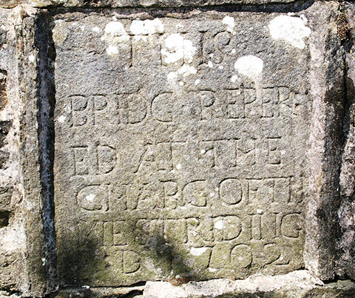
There are some interesting ancient bridges down this part of the dale, one near the Sportsman Inn which is in constant need of repair due to persistent misjudgements by motorists (yes, a further moan about them). Another bridge, near the tiny church which is worth a visit, contains a stone plaque which reads:
THIS
BRIDG REPER
ED AT THE
CHARG OF TH
WEST RIDING
D 1702
Either the original stonemason didn’t plan his work properly or later repairs have obscured part of the wording – but we get the gist.
In the late 1950s, early ’60s, along with many other boys, I would stand on a railway bridge and wait for a steam train to pass underneath. We’d get covered in smoke, steam and soot and that would be considered time well spent in the days before girls and t’ internet came along. To evoke those memories I stood on a bridge at Stainforth this week and waited eagerly for The Dalesman train. For any other sad fools like me, visit this link to see my very short video. https://youtu.be/H4Uc3Cv4CfU
I also managed to capture Galatea near Langcliffe to satisfy those who moaned about not having any train material in last week’s edition of my ‘wot I did on my hols’ summer blog.
When I’m out and about with my Box Brownie (for those not old enough to know, this is a term for a basic camera, and not a nickname for a friend or in this case something to eat) I’m generally pointing it at the landscape. But sometimes the minor detail, which when all added together creates our fabulous Dales scenery, is worthy of attention. Zoom in on a small section of drystone walling for example and you can see art far superior to some of the pretentious guff on show in posh galleries. For the top photo I focused on a tiny section of an ancient footbridge over the beck at Cowgill, between Dent and Ribblehead. You quickly lose count of the number of species crowded together here but they successfully exist together in their little primeval ecosystem. Shame us humans seem incapable of doing the same.
 Let me take you on a little drive around the western Dales. On the one clear day this week I drove along the back roads of Wenningdale from Settle to the Great Stone of Fourstones (pictured below), above Bentham, with the hope of taking some long-distance shots of the Three Peaks and perhaps even the southern fells of the Lake District. Although there was plenty of blue sky above, there wasn’t the clarity. I did manage these photos of the Dales and beyond:


 There is a magical little waterfall as you descend into Deepdale – it’s unnamed on the OS map.