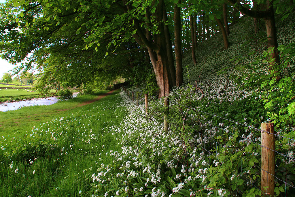
There aren’t many flatish, longish, riverside-ish walks in the upper Dales. Here the becks and rivers are generally young and rash, heading energetically down the hillsides. They provide us with some picturesque waterfalls and quick scrambles, but not many easy, level strolls. One exception is beside the River Dee, near Dent, where I visited this week. (Not the top pic – see later.)
A pleasant figure-of-eight route uses part of the Dales Way long-distance walk. There are good views of Dent (above) and the surrounding hills, and thankfully for my creaking knees, no gradients to speak of along the way. The sound of water cackling over stone, frantic calling between ewes and lambs, and birds being busy doing what birds do in spring made this a very pleasant couple of hours.
Just thought I’d throw this pic in to show that the Dales isn’t all about drystone walls – here near Dent the art of hedge laying can be seen.
I read this week that one Yorkshire pensioner shoots wild birds in his back garden because he “dislikes being disturbed” by their singing. He wouldn’t be very happy round my way at the moment as the swallows are returning after their winter hols abroad. I can’t imagine a world without birdlife. If it is irritating noise he dislikes I suggest he takes the gun down to … probably best not to continue on this line of thought.
From Dent I drove through the Dales calling at Sedbergh, Hawes and Askrigg – stopping off to photograph ponies in front of the Howgills, Cotter Force (above) and St Oswald’s in Askrigg (below). The church is Grade I Listed, dating from the fifteenth century with evidence of earlier building. Afterwards I just had to stop to capture a very different but just as architecturally important Dales barn beside the Ure in Wensleydale (top picture in blog).
I also had a quick trip one evening to Malham where some macho outdoor types were climbing bare-chested above Watlowes. I can think of more relaxing ways of getting a tan.
Photographic highlight of my week though was a trip on Friday evening to Morecambe. Despite living in the Dales, the bay is less than 30 miles away. Seen from the shoreline, the Lakeland Fells were just a grey-blue silhouette across the water. I headed home via the Trough of Bowland, stopping off at Jubilee Tower on Quernmore to witness a superb sunset.
Ribblesdale, of course, provided more spring joy. A short evening wander up the narrow road to Little Stainforth opened up this lovely pastoral scene (below). I’ve taken dozens of photos this week but I don’t want to be that bloke who bores you with his tedious, endless holiday snaps (oops, too late!) so I’ll save some for another day.
Back in Langcliffe, the annual imprisonment of naughty daffodils is taking place …
I was driving back from Malham to Settle at dusk when this strange flying machine buzzed overhead – so low, I expected to hear an almighty crash from over the horizon. Does anyone have any ideas about what it is and why it almost took the aerial off my car roof?
I received a card this week wishing me a Happy Yorkshire Christmas. It got me imagining Santa wearing a festive red flat cap, shouting ‘Ey up! Narthen! Sithee!’ as he travelled across the Broad Acres on a sleigh pulled by half a dozen whippets. Then I read somewhere that some chap was complaining about not seeing any sweeping plantations in the county where Yorkshire Tea is grown. I tweeted that despite the lack of tea-growing, folk can visit the forests of Pudsey where Yorkshire Puddings are scratched from the ground by specially trained ferrets. And that you can watch traditional divers off the coast of Scarborough who risk their lives searching the Great Yorkshire Reef for Yorkshire Mixtures. Yorkshire Parkin is still quarried from prehistoric deposits in Giggleswick of course. And Yorkshire Curd Tarts are produced in darkened sheds throughout the Yorkshire Dales by Yorkshire Women in pinnies mixing Yorkshire Water and Yorkshire Milk while supping Yorkshire Best Bitter. We’re short of nowt here.
I see that Giggleswick Quarry (that’s the limestone one, not the Parkin quarry) has been put up for sale. It will be interesting to see what happens to it – and what is allowed. I always thought that quarry owners in the Dales were supposed to restore any former workings once they’d been plundered, not just sell them off to the highest bidder for the new users to take on responsibility. So I looked on the Dales Environment Network website – it states:
‘We have an obligation to restore quarry sites once we have finished working them, and in the Dales we do so in partnership with a number of organisations such as the National Park Authority, Natural England, the Wildlife Trust and Dales Millennium Trust. Giggleswick quarry was closed in 2009, and is now undergoing the process of restoration. As with Old Ingleton quarry, we will be primarily relying on natural regeneration – however this is being supported by native tree planting and broadcasting of wildflower seed mixes across the site.’
So I’m left a little confused. Not being one of Her Majesty’s card-carrying investigative journalists any more, I won’t be following this up but wonder if anyone else has bothered to ask what’s happening? Perhaps the quarry owners have actually fulfilled their statutory obligations – I don’t know, but viewed from the path above, the quarry just looks like a big Yorkshire Hole.
One hole in the Dales is Birkdale Tarn – the third largest expanse of water in the Dales after Malham Tarn and Semerwater. At 1600ft it’s the highest of the three, best for solitude and hardest to photograph!
It’s a bit black ovver t’back o’Bill’s mother’s.
I couldn’t go a week without a photo of Winskill, could I? ….
Fabulous sky above Ribblehead Viaduct…
Small screens don’t do justice to panoramic views but I recommend looking at this one of the Howgills, taken a little while back, on a computer if possible.
Penyghent made but a brief appearance from under its shroud during the week…
Despite slipping and landing on my backside in the mud, a trip down to Stainforth Foss this week was worthwhile. The repaired packhorse bridge (top photo in blog) looked much better and the river was lively. Here are a couple more photos and video link.
Seven days ago I believed the Dales summer was all over and done with. So what a bonus to have a few pleasant days this week. I’ve been able saunter around the hills and dales with the fleece still tucked away in the bottom of my bag. One day I drove up lonely Kingsdale and pulled in to walk along the old track which leads over to Barbondale. I love the views from up here. Sitting at the top of High Pike at around 1600ft you can see over several dales and north-west to the Howgills. I was pleased the top photo came out as well as it did. The folding hills merge well with the rolling clouds which bubbled up like waves on the sea.
This carved stone sits in a field at a place on the OS map known as Foul Moss, just off the track. It is only a couple of hundred yards away from the County Stone, the point where Yorkshire, Lancashire and Westmorland all meet. If anyone knows the significance of this little stone and carving I’d be interested to hear from them.
Distant mist but the view down Kingsdale from the top gate is always worth a second glanceFrom the Barbondale track the top of Ingleborough can be seenThe first view of Deepdale and beyond as you rise out of KingsdalePhoto-bombed by a horse as I looked towards the Howgills
Later I drove into Dent where I picked up a couple of stock pictures after stopping off at this waterfall in Deepdale.
Earlier in the week I drove up to High Birkwith at the top end of Ribblesdale for a circular stroll around Ling Gill National Nature Reserve. By ‘around’ I really mean right round the edge of the reserve for I wouldn’t contemplate clambering my way through the gill. By all accounts it is an almost primeval landscape of boulders and waterfalls, with dark and dank enclaves populated by rare plants. The short, steep-sided valley has remained virtually untouched from grazing animals and humans. Probably the best website I’ve seen for further details is http://oldfieldslimestone.blogspot.co.uk/2013/06/ling-gill-limestone-wild-and-untamed.html
The Tarn at Newhouses on the way to High Birkwith
The walk, stretches of which were still a tad boggy, takes in part of the Pennine Way and also the Three Peaks route between Penyghent and Whernside. I never tire of the views around this part of the dales.
Park Fell seen from near Nether Lodge (pictured below)
Ling Gill bridge. The National Nature Reserve is in the steep gill which can be seen behind the ruin (below)
Half of last week’s blog disappeared into an internet black hole. Probably my fault. Here’s one you missed of a duck trying to explain the hokey-cokey…
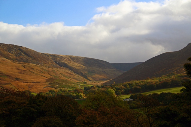
There’s a fabulous 360-degree Dales view from Stone Rigg at the head of Barbondale. If ever you want to know why more parts of this area have been roped into the revised Yorkshire Dales National Park then this is the place to go. Standing on the small rocky outcrops at the top of Stone Rigg – just a short walk from the steep, narrow road from Dent – you see the Howgills to the north. The lower end of the Howgill range is already in the park but further north towards Ravenstonedale is rightly being included later this year. Swinging right you stare across at Aye Gill Pike and down Dentdale to Great Knoutberry, then on to the western slopes of Great Coum and Crag Fell.
Looking north to the HowgillsFrom the head of Barbondale down Dentdale to great Knoutberry
At 180 degrees you’re looking down Barbondale itself with the steep side of Middleton Fell glaring down on your right. I’ve been here several times before and never tire of the all-round beauty. Further down the narrow dale heading towards Barbon is a little boundary stone which signals the end of the current park. The lower slopes of the dale become thickly wooded before it opens out to reveal some glorious views along Lunesdale.
Later in the week I also revisited another part of the new park, heading up Mallerstang and stopping off at the enigmatic 12th-century Pendragon Castle. The view down towards Wild Boar Fell was, as always, a pleasure to see.
From the castle it was on towards Nateby. Gypsies were camped ready for the final part of their annual journey to Appleby – it seemed an appropriate spot for their camp and surely much more of a pleasure for the horses than beside the busy A65 (where they’ve been causing enormous traffic jams). I love the journey between Nateby and Keld through Birkdale. Here is a very different Dales character to my normal Ribblesdale habitat: bleak and rough; fewer walls and tougher sheep. But you’re soon into a greener Upper Swaledale; enclosed by steep sides but gentler, with the young Swale dancing over exposed browned bedrock. A grand drive over Buttertubs Pass to Wensleydale, up Widdale and home via Three Peaks country of Ribblesdale. I might not be exercising my legs much at the moment but my eyes are certainly active.
The bleak and lonely moors of Birkdale
I wonder, had Kirby Misperton fallen within their land, if the Dales National Park would have allowed last week’s fracking fiasco to happen? Seven councillors who are supposed to represent Yorkshire on matters of planning, ignored the 92 per cent of locals and instead pandered to what the government wanted them to do – a government which is currently keeping secret a report on whether fracking causes climate concern. Hell, even Lancastrian councillors had the sense to boot out the get-rich-quick fracking cowboys. Hang your heads, seven shameless Yorkshiremen.
Which brings me on to another whinge I have, stirred up by this week’s ‘news’. There’s a decline, says a study, in the humber of people using regional accents. It seems we are all starting to sound like we come from the south east. That certainly won’t do. And some teachers have been told to change the way they speak to children by cutting down on local accents. Sometimes I listen to people in their late teens/early 20s, using that very boring generic university accent, in which almost every sentence seems to end with a question mark, and I thank mi Mam n Dad for teaching me to speyk Yorksher.
Talking of moaning – an acquaintance was moaning about pot-holes in Ribblesdale’s roads the other week. This week he is moaning that ‘they’ are closing the roads throughout the region to mend those potholes. Now I’m moaning about him moaning.
Bridge of Sighs
I was very saddened to see that someone had a go at demolishing the pretty packhorse bridge over the Ribble at Knight Stainforth this week. Obviously, the person didn’t go out to deliberately wreck the ancient structure – whether it was caused by someone using a sat nav instead of a brain cell, or by careless driving, I don’t know. But it’s going to be costly to repair the National Trust-owned bridge. The original stonework is going to have to be recovered from the river before it is washed away, and the bridge will probably not look the same when rebuilt. It wasn’t meant to take motorised traffic. I realise this will inconvenience a few local users but I think the current diversion via Stackhouse Lane or Helwith Bridge should be made permanent and the bridge left for cyclists and pedestrians only. I’m keeping my fingers crossed that during the Bank Holiday weekend, which brings all kinds of folk to Stainforth Foss, we don’t see more damage or accidents.
It’s been a pleasure hobbling around Ribblesdale this week while spring really blossomed. By the Ribble in Langcliffe were thousands of rampant ramsons like riotious football fans charging down the packed terrace, hopping over the fencing and spilling on to the pitch.
Sitting here listening to the birds and a gently trickling river was simply beautiful. However, one youngster licking its lips as it approached me was a little disconcerting…
Bill Mitchell’s funeral service at Skipton Parish Church on Monday proved to be a fitting send-off for a Dales icon. His children David and Janet spoke eloquently as they recalled life with their famous dad. He would have been very proud of them. After the service I thought I’d pay a private little tribute to Bill by visiting one of his favourite spots. I once asked him to tell me of his best-loved places in the Dales – a terrible question to ask, and one to which I usually give a very wishy-washy answer. He preferred peaceful out-of-the-way locations where he could contemplate life rather than those featuring great long hikes over mountains. He liked Cotter Force (pictured above) and other waterfalls, and also Thorns Gill, near Ribblehead, where I took a little wander on Monday afternoon. The beck was low and the trees were changing colour and losing leaves, which meant I could see more of the quaint old bridge.
When I joined Dalesman Publishing Company in 1993 Bill had retired from being editor of Dalesman and Cumbria magazines some five years earlier but he still contributed to them and for a while continued to edit from home another magazine which the company owned called Pennine Magazine, later to become Peak & Pennine. Alongside Bill I subedited and laid out the pages, the old fashioned way to begin with – cutting and pasting bits of paper for an outside typesetter to prepare for press. Bill was very fond of the magazine. It gave him chance to write about areas and subjects not necessarily associated with the more rural dales region. His interesting and popular Milltown Memories articles stemmed from this. On Tuesday I had the chance of a whistle-stop tour of some of the areas featured in the magazine which sadly is no longer published.
The gritstone towns and villages clinging to the steep hillsides here are full of character. They sit in dramatic country where for centuries Man has tried, usually unsuccessfully, to tame inhospitable land and conditions. The higher boggy moors of the South Pennines are really fit for nothing bar rearing game birds and a few hardy sheep. But it is the perfect place for collecting water, as witnessed by countless reservoirs which supply major industrial towns and cities of the north. They break up desolate landscape and provide some fine photography.
At Dovestone (pictured above), close to where the four counties of Yorks, Lancs, Derbyshire and Cheshire shake hands, the autumn colours brightened up for me what can sometimes feel to be a dark, claustrophobic – but exciting – landscape.
The sky and weather changes rapidly here on the high hills and this has proved inspirational for many leading artists, writers and poets. Holmfirth-based artist Ashley Jackson loves these moors and he has helped people visualise their beauty with the installation of metal frames around the district – see www.framingthelandscape.co.uk. I called to see one at Wessenden, a bleak spot on the edge of Saddleworth Moor, and after a brief stroll around the picturesque Digley Reservoir, it was up the winding route to Holme Moss, 1719ft above sea level. Here another of Ashley’s frames (pictured above) highlights a wide-reaching and varied panorama of moorland, industry and history.
As if the hills aren’t already high enough in these parts, Man has decided to extend his reach even further. Holme Moss transmitter station stretches another 750ft high above the frame, while in the distance the giant TV mast of Emley Moor stands a whopping 1084 ft high with its tip almost touching 2,000ft above sea level. Tall wind turbines grab the considerable breezes to the south-east, while in the centre of the scene the grand Victoria Tower of Castle Hill is clearly visible. While I’m in full-flowing anorak mode, I can tell you that the tower is 106ft high, which means that by standing at the top you are 1,000 feet, plus however tall you are, above sea level.
I drove down to the monument (pictured above) before dusk and although it wasn’t the clearest of evenings the 360 degree views were still a joy to behold. I then watched Huddersfield Town win 2-0 … also a joy to behold (but not as frequently available).
Being very busy for the rest of the week I’ve had little chance to do much more photography or walking, but strolling into Settle along the Highway on Friday I was rewarded with a view of some fine autumn colours.
Pleasing news this week is that the government have at last (it’s taken more than two years) decided on enlarging the Lakes and Dales national parks to bridge the gap between the two. Important places like Orton Fell, Mallerstang (pictured below) and the northern end of the Howgills will from next summer fall under the Dales authority. The government now has to find a way to pay for this extension at a time when they are slashing all park and local authority budgets. Will they eventually decide to sell off the Dales National Park to the highest bidder? Will my forecast in an earlier blog of there being a McDonalds or a Starbucks at the top of Penyghent one day become reality? Let’s hope they remember that the national parks were created to protect our countryside for future generations, not to solve financial cock-ups, or make someone a fat profit, or place in private hands.
Standing on top of Great Stone of Fourstones, which marks the Yorkshire border with that other county whose name escapes me, you can enjoy one of the best ‘driveable’ views of the south-western dales. The Three Peaks, Gragareth, Howgills and the distant jagged teeth of the Lakeland Fells are laid out before you. The 16ft-tall glacial deposit is the only one of four large stone outcrops remaining on this spot on Tatham Fell, near High Bentham – the others probably having been broken up for buildings and tools. I wanted a view but not a trek on Wednesday and this monolith once again proved an ideal location. With a 200mm zoom lens I was able to make out the layered-cake effect of Ingleborough and capture Whernside looking particularly dominant above Twisleton Scar.
After writing last week’s blog on Sunday I wandered up Ribblesdale and on to Stainforth Foss where dozens of people were on salmon-leap-watch. I wondered whether there would be any conflict here today, as just a few yards down river from the falls were two anglers … salmon fishing? Poaching? I didn’t stop to find out, but headed further downstream to Langcliffe where the colours on the riverbank and millpond stood out starkly against a drab sky.
I reckoned this week would be one of the best for capturing the changing colours and I was right. On Monday I took a stroll around Malham Tarn – almost ignoring the tarn and concentrating on the surrounding bogland, shrubs and trees. The last time I’d been in this woodland I’d been startled by a deer but there was no sign this time.
The blue sky came out later and I got some good shots of the eastern side of Penyghent. I was also able to snatch some great scenes around home later that day in the evening sun.
St John the Evangelist in Langcliffe might not have the history or ancient architecture of older dales churches but it is certainly a pretty Victorian building within well-kept grounds and it looks a picture when caught in the evening sun.
At this time of year I like to raise my eyes above the area’s wonderful landscape and take in the ever-changing autumn sky. It’s been a treat this week with a variety of clouds, shades, and sunsets. On Friday I sat above Winskill and watched an invasion of aliens beaming up all before them … I woke up Saturday morning with ‘REJECT: Beyond Best Before Date’ stamped across my forehead.
Yesterday, after strolling by the Ribble in some glorious changing light, I drove up to the old road between Settle and Feizor to watch the sunset. I also waited as long as I dare for an unsteady hand-held night shot, to capture an outline of Ingleborough.
You will have already guessed that my picture wasn’t taken in the last few weeks. But as I passed this spot just above Sedbergh today in dreadful weather I was nevertheless reminded just how beautiful the Howgills are. I’d like to register a vote for this view of the western-most edge of Yorkshire as one of Ashley Jackson’s Framing the Landscape @framinglandsc candidates, just so this far-flung part of the county is not forgotten.
 There aren’t many flatish, longish, riverside-ish walks in the upper Dales. Here the becks and rivers are generally young and rash, heading energetically down the hillsides. They provide us with some picturesque waterfalls and quick scrambles, but not many easy, level strolls. One exception is beside the River Dee, near Dent, where I visited this week. (Not the top pic – see later.)
 A pleasant figure-of-eight route uses part of the Dales Way long-distance walk. There are good views of Dent (above) and the surrounding hills, and thankfully for my creaking knees, no gradients to speak of along the way. The sound of water cackling over stone, frantic calling between ewes and lambs, and birds being busy doing what birds do in spring made this a very pleasant couple of hours.

 From Dent I drove through the Dales calling at Sedbergh, Hawes and Askrigg – stopping off to photograph ponies in front of the Howgills, Cotter Force (above) and St Oswald’s in Askrigg (below). The church is Grade I Listed, dating from the fifteenth century with evidence of earlier building. Afterwards I just had to stop to capture a very different but just as architecturally important Dales barn beside the Ure in Wensleydale (top picture in blog).