Seven days ago I believed the Dales summer was all over and done with. So what a bonus to have a few pleasant days this week. I’ve been able saunter around the hills and dales with the fleece still tucked away in the bottom of my bag. One day I drove up lonely Kingsdale and pulled in to walk along the old track which leads over to Barbondale. I love the views from up here. Sitting at the top of High Pike at around 1600ft you can see over several dales and north-west to the Howgills. I was pleased the top photo came out as well as it did. The folding hills merge well with the rolling clouds which bubbled up like waves on the sea.
This carved stone sits in a field at a place on the OS map known as Foul Moss, just off the track. It is only a couple of hundred yards away from the County Stone, the point where Yorkshire, Lancashire and Westmorland all meet. If anyone knows the significance of this little stone and carving I’d be interested to hear from them.
Distant mist but the view down Kingsdale from the top gate is always worth a second glanceFrom the Barbondale track the top of Ingleborough can be seenThe first view of Deepdale and beyond as you rise out of KingsdalePhoto-bombed by a horse as I looked towards the Howgills
Later I drove into Dent where I picked up a couple of stock pictures after stopping off at this waterfall in Deepdale.
Earlier in the week I drove up to High Birkwith at the top end of Ribblesdale for a circular stroll around Ling Gill National Nature Reserve. By ‘around’ I really mean right round the edge of the reserve for I wouldn’t contemplate clambering my way through the gill. By all accounts it is an almost primeval landscape of boulders and waterfalls, with dark and dank enclaves populated by rare plants. The short, steep-sided valley has remained virtually untouched from grazing animals and humans. Probably the best website I’ve seen for further details is http://oldfieldslimestone.blogspot.co.uk/2013/06/ling-gill-limestone-wild-and-untamed.html
The Tarn at Newhouses on the way to High Birkwith
The walk, stretches of which were still a tad boggy, takes in part of the Pennine Way and also the Three Peaks route between Penyghent and Whernside. I never tire of the views around this part of the dales.
Park Fell seen from near Nether Lodge (pictured below)
Ling Gill bridge. The National Nature Reserve is in the steep gill which can be seen behind the ruin (below)
Half of last week’s blog disappeared into an internet black hole. Probably my fault. Here’s one you missed of a duck trying to explain the hokey-cokey…
I took a few tentative steps outside Yorkshire this week. I must add a rider here: many of those steps were within the new Yorkshire Dales National Park boundary. You know what? It’s pretty good – Westmorland and Cumberland have quite a bit going for them. Just south of Appleby is the impressive Rutter Force which just sneaks into the recently extended park. The mill there is now accommodation, reached by a ford which even on a fairly calm day like this I wouldn’t cross in my little car.
Busy Appleby is just outside the Yorkshire park boundary but a fine place to visit – made even better by being reachable via the Settle-Carlisle Railway. Before this visit I hadn’t realised the extent Appleby had suffered from the last major flooding. Many riverside properties are still being renovated or drying out. Flood prevention schemes along the riverbank are being implemented.
A definite autumnal look beside the Eden in Appleby
They like to take care of their trees in Appleby – this one has a nice woolly coat to protect it from the strong north-easterlies.
The red sandstone St Lawrence church in Appleby – parts of it date back to the 12th century.
I was looking forward to some extensive views down the Eden Valley and Mallerstangdale but sadly the mist never really cleared. Cloud clung to the tops and from a distance looked like a layer of snow on the east. This scene was taken from Pendragon Castle.
Back in real Yorkshire
In amongst lengthy thunder and lightning storms this week there were a couple of decent sunsets. The shot below was taken at Winskill Stones above Langcliffe.
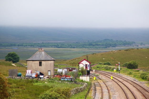
Last Sunday was one of those grey Dales days which have been all too familiar this summer. Nevertheless I drove to Ribblehead where often on a summer Sunday there can be more people than on Blackpool prom – but it wasn’t too bad. Knowing that a steam train was due to be heading back from Carlisle I walked up to Blea Moor until my head almost reached the height of the low cloud. Approaching Blea Moor signal box I recalled a diary piece I wrote around five years ago for Dalesman concerning the lonely house which is situated next to the box. It was in a poor state and the ‘garden’ was covered in tons of scrap metal – a real eyesore. This was the first impression many travelers got of Ribblesdale as they entered from the north-west and so the owner was asked to clean it up, which he did to a fashion. As seen in my pic above, It doesn’t look too good again today and the house seems deserted – a great shame.
However, looking back down the dale I managed to capture something more cheerful as a brief shaft of sunlight illuminated the valley while Penyghent remained shrouded in mist.
I could hear the cat growling while he was sitting on the internal window ledge. This usually means there are birds outside which he can’t get at. Together we watched a group of sparrows and finches having a bath in the puddles – but our thoughts about ‘capturing’ them differed somewhat.
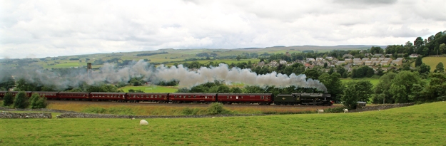
It’s steam train season here in Ribblesdale and during the peak summer period there can be five a week passing up and down the Settle-Carlisle railway. They attract people to the area and help keep the grand old line open. The politically correct may consider these great machines as eco-unfriendly. If they were running an hourly service every day of the year I might agree with them. But I’d still rather see one of these chugging up the dale than a hundred polluting cars any day. On Tuesday I captured this one as it was leaving Settle.
With a good forecast for Wednesday I’d planned to pollute the dales myself by driving over to Wensleydale through Mallerstangdale, then head back via Birkdale and Swaledale. Perfect timing saw me meeting another steamer on the line near Aisgill (above pic) where the line leaves Yorkshire and enters Westmorland. This is the final major climb for the train and a popular location for train buffs.
On clear days the views as you climb the road out of Nateby are breathtaking. With the Eden Valley, North Pennines, Howgill Fells then bleak Birkdale and Ravenstonedale plus the uppermost reaches of Swaledale all visible, this journey is one of the best in the dales. In the distance can be seen the Air Traffic Control’s radar station on top of Great Dun Fell (2782 ft), in the North Pennines. The private road which ascends to the ‘giant golf ball’ is the highest surfaced road in England. Slightly further up the Pennine chain is Mickle Fell (2585 ft) whose summit is the highest point in Yorkshire (proper boundary).
Sadly I couldn’t manage the rest of Swaledale as the road was shut from near Thwaite (where I took the above pic) because of work on Usha Gap Bridge. Not for the first time a vehicle failed to negotiate the narrow bridge – and also Ivelet Bridge further down the road. These bridges weren’t built for big loads so the authorities need to do one of two things: forget about preserving the past and knock them down and build ones suitable for the 21st century; or ban unsuitable vehicles from the road. Knocking some common sense into drivers might also be a solution.
After being in the car for such a long period I needed a walk that evening and managed to capture this heron when it dashed passed me as I walked by the Ribble. Technically it’s not a good shot but it does show the superb aerodynamic nature of this ancient bird.
Thursday: the farmer created a new view on my regular walk by cutting one of his fields, while back in the village the memorial fountain was colourfully dressed for today’s VJ Service.
Lo and behold, I also encountered another train this time completely by accident. As I walked to the Hoffman Kiln in Langcliffe I saw photographers waiting for the arrival of the engine Galatea. The footpath is right next to the line and you can feel the ground rumble as the great monster gets up close and personal.
Yesterday was a big day in the village as the efforts of talented locals were on view at the annual show. Sadly I was otherwise engaged but I did participate and was lucky enough to earn a first for three of my photos and a second for this black and white photo of New Street…
Another place on the western fringes of proper Yorkshire which deserves ‘framing’ (see previous blog) is Mallerstang. The B6259 which runs through this lovely dale starts off in Yorkshire, following the Settle-Carlisle railway, and enters Westmorland around Aisgill. To the east rises Great Shunner Fell while to the west (pictured) is Wild Boar Fell. The river Eden flows down this valley and it certainly is a paradise.
 Seven days ago I believed the Dales summer was all over and done with. So what a bonus to have a few pleasant days this week. I’ve been able saunter around the hills and dales with the fleece still tucked away in the bottom of my bag. One day I drove up lonely Kingsdale and pulled in to walk along the old track which leads over to Barbondale. I love the views from up here. Sitting at the top of High Pike at around 1600ft you can see over several dales and north-west to the Howgills. I was pleased the top photo came out as well as it did. The folding hills merge well with the rolling clouds which bubbled up like waves on the sea.