Bronte shame, sailor’s trousers, embarrassing falls and yet more flooding


farpyg

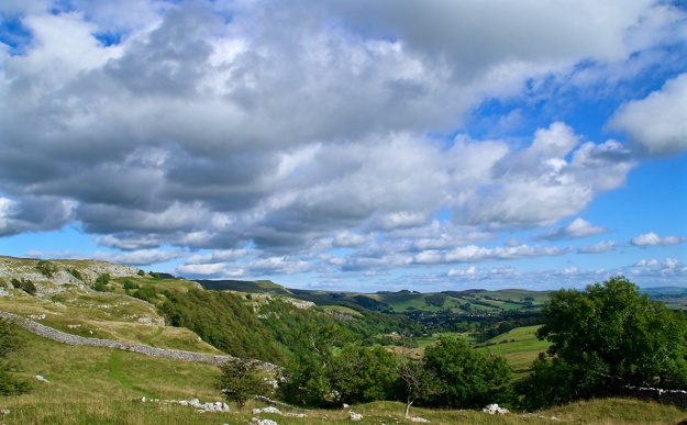
The weather gods granted me a day out on Wednesday – as my mum used to say, there was ‘enough blue sky to knit a pair of sailor’s trousers’ — so I enjoyed a drive and short walk along and beside the Stainforth to Halton road in the morning, then a trip to Malham from Langcliffe in the afternoon. Penyghent looked resplendent – seen above from Dale Head – while at the Giant’s Grave there was still plenty of water around to creatrockfalle a splash or two. Here the water can take several different directions, filling huge potholes before eventually finding a way down Penyghent Gill and into Littondale.

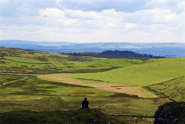
In the upright photo showing the moors above Halton Gill in the distance, is evidence of a recent rockfall probably caused by the storms. The tree hangs on precariously.

4wayfall

Farms along Henside Road from Cowside to Arncliffe via Malham Tarn are often cut off during winter. I recall Bill Mitchell writing a piece for Dalesman about a family stranded at Capon Hall Farm for several weeks during the bad weather of (I think) 1962. Here’s one of the farms, with Malham Tarn visible in the background. There was a light sprinkling of snow/slush around the higher moors on Christmas Eve but nothing to bother these hardy farmers too much … yet.

capon

I like seeing the fields above Malham, and the limestone of the cove, in the early evening sun when most of the tourists are making their way home. The animals graze peacefully and the whole scene takes on a more pastoral feel.

malham

Embarrassing Falls

The heavy rain has reintroduced many waterfalls which are usually only observed when the underground channels are full. The historic view of water tumbling over Malham Cove last week is a prime example, but there have been many other reappearances too throughout the Yorkshire Dales. This one on the Horton side of Selside doesn’t often teem over the top. It’s a fine little fall which according to the Ordnance Survey doesn’t have a name. Ended-on-my-arse-here Falls would be appropriate, for me at least. Muddied and briefly embarrassed, hoping that no one witnessed my mishap, I walked towards High Birkwith and back along the Pennine Bridleway.

embarrassing falls

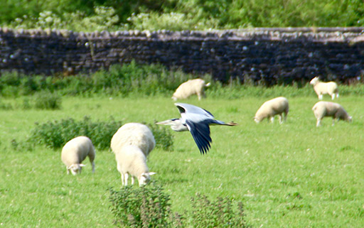
On returning home this little chap was waiting for me. He posed for one picture on a neighbour’s bench, then flew off. I haven’t seen him since – perhaps his mission is to say hello to everyone in the dale over the Christmas period.

robin

Even more rain towards the end of the week meant extended time on the computer or watching some mind-numbingly tedious Christmas TV programmes, usually involving ‘celebrities’ – most of whom I’ve never heard of. Can we look forward to a series titled ‘Celebrities on Benefits’. Only a joke, before people write in. It’s no laughing matter being unemployed and anyway, whingeing about TV seems churlish considering what happened yesterday. The floods in the north have caused devastation and severely disrupted the lives of many thousands of people. I had to curtail my journey down the Aire Valley yesterday – I had never seen it so badly flooded – and I was lucky to get back up to Ribblesdale before the roads were closed or impassable. My heartfelt sympathy to everyone affected. Sorry, Mr Cameron, you’re going to have make yet another journey oop t’north for a photo-shoot to show the nation what a caring PM you are.

Bronte shame

Bronte panopticon

A few miles from Ribblesdale is the once-deserted hamlet of Wycoller which contains a partly ruined hall, thought to be the setting for Ferndean Manor – the home of Rochester in the Charlotte Bronte novel, Jane Eyre. The place underwent a bit of a revival a while back but is now under threat again, along with the Wycoller Country Park (pictured above at the Panopticon) and the Bronte Way footpath. All are under the care of Lancashire County Council, but it is now planning to completely close down the management, maintenance and ranger service. If this happens visitors may no longer be able to see the great aisled barn or use the countryside activity centre. The visitor toilets will close and the privately run cafe and shop are unlikely to survive. Wycoller hamlet is one of the area’s prettiest destinations, attracting thousands of Bronte fans, and is served by dozens of volunteers. It is managed by a countryside ranger with a modest budget, so any cost savings from closing it down will be negligible. I first became interested in the area’s literary connections and fascinating countryside some forty or so years ago, and believe it would be a shame if this key part of the Bronte heritage was lost forever. If you agree sign this petition or contact the council https://t.co/dbEffg09af

Ribblesdale images

The second instalment of my ‘Year in Ribblesdale’ picture gallery shows snaps taken between May and August inclusive. The choice was difficult as there were some lovely days during spring and summer. September to December photos follow next week.

It's all Nature's fault

atterscarA major fault led to my best moments this week. I’m talking about the Craven Fault, caused by a prehistoric act of Nature which created some of the country’s most magnificent and intriguing landscapes. A walk following the fault-line from Clapham in the west to Grassington in the east would surely be one of the most spectacular trails in Yorkshire – over to you, trailblazers. I trod two sections this week – the first from near Feizor across to Giggleswick Scar where views down Ribblesdale and the floodplain early evening on Tuesday were exceptional.
gigscar
On Friday I walked the Settle Loop – part of the Pennine Bridleway – which includes views of the fault-line over Malham and Malham Moor. For me though, the tiny valley of Stockdale provides one of the greatest panoramas. Heading from the Malham direction, the Settle Loop reaches the top of Stockdale and squeezes between the Rye Loaf Hill and the limestone scars of Attermire and Langcliffe. Here Warrendale Knots stand guard on the border between limestone and gritstone, and here the grand sweeping valleys of Ribblesdale and Airedale open up before you. Being there on a warm summer’s day certainly makes you feel glad to be alive.
stockdale

viewer
(That’s not me in the picture – hope you don’t mind whoever you are.) Back to Sunday … after I’d written last week’s blog the day brightened up so I drove to Selside and a nice little photo spot near the start of the track to Alum Pot. Here Penyghent is perfectly framed by the trees which somehow grow from the limestone pavement.
pygtree
smallsignOn Monday I strolled from the village up to Winskill to find that one of my favourite pointy-signpost-photo-foregrounds had been switched for a short stumpy little effort. I suppose it helps open up the view a bit but I like signs that have place-names on them. Perhaps the authorities have been instructed to remove all signs containing names because there’s an imminent invasion threat?

I got the rare urge to desert the Dales on Wednesday and use my senior railcard on a trip to York. Unfortunately, most of the rest of the holidaying population of the UK and beyond had decided on the same destination. As you’ll gather, I’m not one for crowds but the experience was bearable thanks to the many attractions of this magnificent little city, and I saw many sights and heard sounds I’d never normally come across back home …
musicmagicball tower

yorkwallsWith the sun still having its hat on yesterday I walked up to Castleberg Rock to take a panoramic view of Settle and Giggleswick. I made a very short video with my normal camera – something I’m not very good at, as you’ll see here …


Vapour, steam, bridges, foxes, reflections and ruins in Ribblesdale

vapour

I never left Ribblesdale during the last seven days – as my photo diary testifies. Poor weather for June really, so I kept local. But it all started so promisingly. The dale woke up on Monday to a bright blue sky littered with party streamers – vapour trails, which I blamed on Lancastrians on Facebook. I’d presumed they were sending planes from Manchester to pollute our Yorkshire skies. However, I learned later that the majority of them came from London – even worse.
The early stroll took me by an extremely low river Ribble where I saw a duck with eight cute ducklings struggling to keep up. I ‘m annoyed with myself for not getting a better photo of them but I couldn’t get close enough. The duck stayed hidden as a large grey heron was stalking the riverbank. It flew off as I approached and again I cocked-up the photo.

ducklingsheron
I did, however, get some some nice shots of cows drinking from the Ribble and spotted this amazing upside down hovering cow. It’s standing on the opposite bank, hidden behind the tree branches, but it’s reflection along with that of the sky is sharp on the still water of the river.

cow
From then the weather took a distinctly downhill turn. I got soaked on Wednesday lunchtime at Helwith Bridge waiting for the Fellsman steam train on the Settle-Carlisle. The engine was Leander 45690 for those who fret about such detail.  I don’t – but I love the spectacle of steam. The train makes such a dramatic entrance, full of energy and exuberance. The regular train snappers had taken up position at one side of the bridge but I thought there might be a more unusual portrait from t’ other, and was rewarded with this shot. I drained out what tiny specks of colour remained amongst all the rain, mist and steam.

fellsmansmall
Later that day I wandered down the Pennine Bridleway near Selside with the double aim of seeing the train on its way back and also to look in on a unique bridge over the Ribble. I was able to get up close and personal with the train as it coasted down the dale, reminding me of an old toy train set.

trainclose
When I edited Dalesman I witnessed the opening of a special wooden-arched bridge taking riders, cyclists and walkers over the river as part of the 200-mile Pennine Bridleway. At 174-feet long, Far Moor Bridge is said to be the longest of its kind of structure anywhere in the world. I remembered it as a bright, shiny piece of architecture, a little garish for its situation, but now it has weathered and is becoming part of a scene rarely visited by the general public. And apart from a couple of cavorting oyster-catchers there was no other life on this world record holder today.

bridge
A record for me was the sight, for the first time, of a fox prowling these parts. I’d no chance of photographing it as it disappeared as soon as we saw each other. It’s pretty rough land here, partly a flood plain, but there were lambs about and I wondered whether the farmer knew of the fox on his doorstep.

ruinrib
There’s also an abandoned farm building here. The land is bleak, the weather was dismal, and the derelict building reminded me of a poem I’d started to write a while back but never really developed:
Memories swirling around
silent stubborn stones
are recalled only by the ghosts
of those who once breathed
within the now crumbling walls.
They opened its doors
with faith and hope
of taming land so barren and wild.
No dreams of great riches —
enough to get by would suffice:
clogs for the children, meat for a pie.
But Nature at its wildest and meanest
knows nothing of sympathy
— or hardship or pain.
The futile battle was lost
and now Nature reclaims
what is rightfully hers.
Once a welcome refuge
for those who toiled the land
lies abandoned and forlorn,
inhabitants long gone —
only their memories swirl around
those silent stubborn stones.

I'm no NIMBY but…

greengate

It’s not so long ago that the government’s major political push concerned letting local people decide on local matters – it was called Building the Big Society wasn’t it? I presume from the decision last week to allow the construction of yet more housing in my village of Long Preston in Ribblesdale that the Big Society idea has now been abandoned.
Residents didn’t want any more housing, the Parish Council were against the development and the Highways Department objected to plans for the site. However, the Yorkshire Dales National Park’s appeal inspector, Norfolk-born musician William Weston, gave the go-ahead for the development.
Well, at least the park authority can can say to the faceless Whitehall bureaucrats ‘look what good boys and girls we are, we’ve ticked one of your required boxes’ and provided some ‘much-needed’ and also ‘affordable’ housing.
Hands up anyone who knows what ‘affordable’ means in the context of housing.
The site on Green Gate Lane lies within the Long Preston Conservation Area and I have to admit it is currently a little run down, but that in itself doesn’t necessarily mean it must be turned over to a developer who then makes a fat profit at the expense of a lot of misery to others.
We are talking here of 13 houses – maybe not a lot for a town but a fair percentage of a small village – perhaps 300 extra cars journeys per week down a single track lane which joins on to School Lane (self explanatory) then on to the busy A65 (which in Long Preston alone feeds 30+ direct vehicular accesses).
The cottage on the left of my photo at the junction between School Lane and Green Gate Lane was partly demolished by a wagon trying to negotiate a left turn a couple of years ago.
The authority claims there isn’t enough housing in the National Park yet hundreds of properties in Long Preston and elsewhere in the Dales are second homes or holiday lets. Local estate agents are packed with houses for sale. And what is the point of building more houses when there have been very few new jobs created in the vicinity for donkey’s years, and also the schools and authorities are scratting round for funds and resources.  I know first hand that  slow internet connections in the Dales drastically prohibit the creation of new businesses for employment.
I get the feeling that the park cares little for Long Preston – you’ll not see one of those quaint little sheep motifs signifying you’re entering the National Park in this village, despite Long Preston being the park’s ‘gateway’ from Lancashire.
I wonder what the planners’ decision would have been had someone applied to turn the site into a horse riding centre – or even a ‘horse hotel’ for the newly designed Pennine Bridleway which passes close by – which would certainly have benefited the community? Or how about a proposal for a youth centre or hard-play area for local children? Unfortunately these wouldn’t have ticked any boxes.
The thin edge of the developing wedge was pierced into Long Preston a few years back and it is now pushing open the door even further. I’m no NIMBY, I care about fair play and this Dales community.

%d bloggers like this: