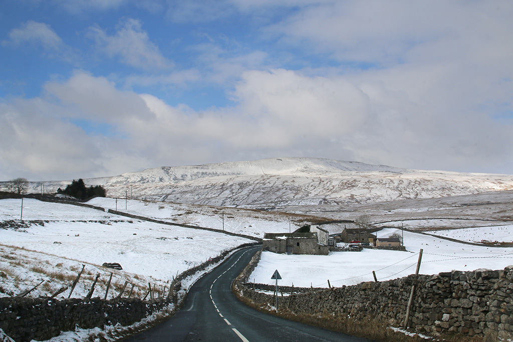
I suppose I have to talk about this week’s weather here in the Dales. As a nation we’re not very good at dealing with cold winds, snow and ice, are we? Thankfully, there are a lot of individuals who can cope – and not surprisingly they tend to live in the country’s higher, more exposed regions.
I had an early* walk in a blizzard for some emergency tea bags one day and saw that a farmer had been up early* to bring his sheep down off the hills and spread out some hay on a low-lying field for his animals. (*The difference between my retirement early and a farmer’s early is about five hours.)
Dales hill-farmers knew what was coming and when it would arrive; they were prepared, took action when needed and just got on with dealing with the job without much fuss. On TV I heard someone complaining because he was being restricted to driving at 30mph in his 4×4, and another person moaning about her recycling bin not being emptied. Before I start on a Jonathan Pie-style rant (he’s brilliant, by the way) I’ll move on …
Battling through a blizzard in search of Yorkshire Tea. Below, I did check to see there was no one asleep on the bench.
My son ‘kindly’ reminded me that I was a child during the bad winter of 1962/3 by asking what it was like in those days. I lived in a town in those days but there were plenty of hills, and I remember the enormous icy slides and much sledging … and scraping ice from the inside of our bedroom windows.
He and I have also being trying to identify paw prints in the snow around our houses. Stray dogs seem to be the most numerous – I say ‘stray’ because I’d hate to think pet owners were chucking out their dogs on such cold nights.
Left to right: fox, dog, cat, badger.
Photography-wise, I’ve not felt inclined to dig out the car for a drive around the Dales looking for stunning snowy scenes – I’m not sure I can justify that heading into the wilds to take pictures is a ‘life-or-death journey’ (unlike the aforementioned tea-bag catastrophe). But I have managed some local shots …
Frozen mill pond, LangcliffeSnow drifts between Langcliffe and SettleSt John’s LangcliffeMill pond overflow, leading to the Ribble.Snow-bound lane from Langcliffe.Snow-topped rubble on the Ribble.Wintry sunset over Langcliffe.
Train tannoy: “Ladies and gentlemen… as we cross the famous Ribblehead Viaduct, on your left you will see absolutely nothing; on your right, there is a very wet bloke with a camera.” Walking round Ribblehead when the rain is traveling sideways, you quickly learn which items of your gear warrant an all-weather tag. I hope Santa is well prepared, because there’s going to be a lengthy ‘I want’ list from me. My ‘fully waterproof’ bag ended up with a puddle in it – at least I can confirm the bottom doesn’t leak. (By Friday many trains along the Settle-Carlisle route were cancelled due to flooding. At one point in the Eden Valley the river was over a mile wide.)
A brief respite from the rain on Friday tempted me out to do a little long-exposure photography – not everyone’s cup of tea, I know, but a useful skill to learn properly. There was probably a bit too much water, flowing too quickly, down Clapham Falls to get a satisfactory ‘silky’ effect. But while in the village I couldn’t stop myself taking the stock photo across old Brokken Bridge. This scene always makes a good in autumn or winter photo.
This tiny waterfall in the former quarry at Ribblehead appears quite angelic and there’s even a shrouded figure merging. I did the short ‘green’ walk around the Ingleborough National Nature Reserve (which includes the quarry). Although the tops of Ingleborough and Whernside were shrouded in cloud, Penyghent could still be seen beyond Gauber and Colt Park.
I was so bored during the poor weather this week that I actually started to sort out a cupboard where books and other bits had been tossed when I first moved into the house. I soon stopped though when I came across a 1920s guide book to Ingleton. It’s a fascinating window into life ninety years ago. In those days tourists flocked to this part of the world mainly by rail and charabanc – but increasingly by road, as reflected by the adverts and editorial. There were once two railway stations serving the village – one, run by Midland Railway company, was where the village community centre now is in the car park, and the other was at the Thornton side about a mile away, operated by London & North Western. At one time, to change trains from one operator to the other, passengers could pay a penny fare to cross the viaduct between the two stations and enjoy the view.
You can view the whole leaflet by clicking on the link below. (Press esc to return to this page if viewing on computer.)
If you’re on a mobile click here to view the Ingleton Guide
NB I have tried to check copyright details on this publication. The publishers, Ingleton Advertisers Association, no longer exist. If anyone knows of a copyright holder please let me know and I will gladly acknowledge them.
Yesterday afternoon I took an exhilarating short walk with Desmond (the storm, not a new friend) around Langcliffe. I thought, once you’re wet it doesn’t really matter does it? The route of my regular jaunt by the Ribble is usually alongside the river bank… there appeared to be this small puddle in the way so I gave it a miss.
Having my regular walk disrupted is, of course, a minor inconvenience compared with the problems being caused by Storm Desmond. Some of the flooding in the region and further north is catastrophic for many people and will affect their lives for many months, if not years. The government is willing to spend millions every night on bombing Iraq and Syria in the belief this will protect us against terrorists, but it has actually held back money for properly protecting some towns and villages in the North West from flooding. But then again, it wasn’t London under attack from Mother Nature was it, just those uncouth tribes of the North.
Feedback
Talking of uncouth, I’d like to say to an old friend that his suggestion for the origin of the name Braithwaite Wife Hole, is totally wrong and uncalled-for. My thanks to those others who tried to decently explain the sinkhole’s name mentioned in last week’s blog. In what must be one of the longest book titles going (‘A descriptive tour and guide to the lakes, caves, mountains and other natural curiosities in Cumberland, Westmorland, Lancashire and a part of the West Riding of Yorkshire’) John Housman, writing in 1800, calls it Barefoot-wives’ Hole. This name is also found in West’s Guide to the Lakes, 1778/1821 and on old maps dating as far back as 1760. A map of 1890, however, shows the name has been changed to Braithwaite Wife Shake Hole. Just like with many place-names and surnames, early scribes often misunderstood local terms and accents when it came to writing down terms that had previously been passed down through generations of verbal history, so perhaps the original name will remain a mystery – unless you know differently.
 I suppose I have to talk about this week’s weather here in the Dales. As a nation we’re not very good at dealing with cold winds, snow and ice, are we? Thankfully, there are a lot of individuals who can cope – and not surprisingly they tend to live in the country’s higher, more exposed regions.
 Dales hill-farmers knew what was coming and when it would arrive; they were prepared, took action when needed and just got on with dealing with the job without much fuss. On TV I heard someone complaining because he was being restricted to driving at 30mph in his 4×4, and another person moaning about her recycling bin not being emptied. Before I start on a Jonathan Pie-style rant (he’s brilliant, by the way) I’ll move on …


