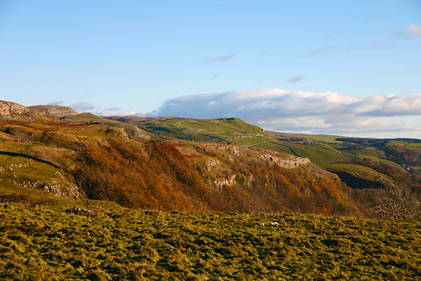
I’m working on a new feature for The Countryman called Classic Countryman in which I will reproduce some fine writing from the magazine’s archive. One series I’ve enjoyed researching is titled ‘Why I live in the country’ written by well known people in the 1930s. They talk about ‘getting away from the madness of the city’ and enjoying the ‘peace and quiet’. For me the main reason ‘Why I live in the country’ is being able to absorb views such as these looking over northern Ribblesdale this morning. You just don’t need any fancy words, do you?
The mist was hanging low over the moors above Stainforth in Ribblesdale this morning. Look at the top of my photo of Catrigg Force and you’ll see just how low. Following the last time I’d puffed and wheezed my way up the steep track from the village to the falls, about two years ago, I’d promised myself that next time I’d carry a tripod with me to take one of those fancy waterfall shots that arty photographers like to fashion. But I forgot the tripod again. The sound of cascading water echoed around this great amphitheatre, but with no birds chirping and a lack of wind to rustle the trees, today it felt an eerie place to be on my own.
This shot is looking back at yesterday’s location – Giggleswick Scar is middle right looking down on Settle – and was taken from Hunter Bark this morning just before heavy clouds moved in. Hunter Bark is the name of the highest point on the ancient track over the hills between Long Preston and Settle in Ribblesdale. If you start from Long Preston railway station you’ll climb a steady 1,000 feet to the trig point on Hunter Bark where you’ll be rewarded with a superb 360 degree view of the region. On the ascent from the village you’ll also see the mazy path the meandering River Ribble makes as it snakes down the dale, as well as the hazy mass of Pendle Hill dominating the distant horizon.
The Yorkshire uplands were certainly no place to be baht ‘at today. I squeezed in an hour on the limestone above Giggleswick Scar after lunch. By gum it weren’t half nithering but the views over Settle and down Ribblesdale were splendid. Managed to slide on my backside through freshly deposited cow muck… and had to drive home baht trousers.
I have this sort of hippy style belief that rivers don’t have a start and finish but are just a continuous flow of water in a cycle involving clouds-land-sea-clouds. I was asked the other day where the River Ribble starts – having given my hippy theory and receiving a blank look in return, I went through the stock answers. But I do wonder why humans feel the need to have a beginning and an end to everything? We must have a measurement too – how long, how high, how deep, how wide… etc; we’re always trying to portray something that’s natural in terms of a man-made unit. Perhaps it’s just another of our attempts to feel in control of the natural world. Instead of calculating it we should just embrace Nature, like a true landscape artist would. I told my friend that there is a difference between the ‘source’ and the ‘start’ of a river. The Ribble’s source is mainly the watershed of Cam Fell and surrounding fells. Water trickles down the fells forming Cam Beck, Gayle Beck and lots of smaller tributaries which join to form the Ribble near Selside, at the place shown in my photo – a rather boring ‘start’ for this mighty river on its 75-mile voyage to the Irish Sea don’t you think? I prefer my hippy idea.
I also caught some lovely autumn light and a cloudless sky above Penyghent on my way back down Ribblesdale today.
The seven-mile drive from Stainforth in Ribblesdale to Halton Gill in Littondale was a delight this morning. There was just a touch of frost remaining in Silverdale (through which the road runs) as the sun began to peek over the top of Fountains Fell and light up the eastern flank of Penyghent. The picture is taken from just above Halton Gill looking down Littondale towards Arncliffe. I hope you realise I risked my life just to bring you this photo – there was an enormous bull beside the road where I pulled in. Luckily, I think his main interest was in eating to regain his strength after having a ‘busy’ night on the moor.
Scaleber Foss is a lovely location a mile or so above Settle in Ribblesdale on the road to Kirkby Malham. I got caught in a brief hailstorm while there this morning but managed a couple of photos before the soaking. Now, as I look out of my window while typing this blog, fluffy clouds are moving quickly across a pretty blue sky above Scaleber – such is life in the dales. Scaleber Wood is a Woodland Trust property and provides some good walking as well as the series of waterfalls. Foss is an old Norse word for fall and it is said that many Yorkshire words developed from the settling of Scandinavians in the county. I recently discovered that my Y-chromosone male line stems from the oldest tribe to have inhabited Europe (uninspiringly called Haplotype I, mutation M253). They lived in Scandinavia from before the Ice Age, then after the glaciers retreated 15,000 years ago began to spread to the British Isles and elsewhere. So perhaps it was one of my ancestors who brought with him endearing terms such as ‘sithee, eyup and what’s tha laikin at?’.
According to the Guardian, Yorkshire is ‘actually four counties’. I almost spat out my tea before I realised that I’d actually paid for it therefore it shouldn’t be wasted. So I flung my flat cap at the ferret instead. Calm down, I thought… if someone was to ask me anything about Middlesex what would I answer (is it a London suburb?). Yesterday I watched a swollen river Ribble flowing under the smart bridge at Paythorne (picture). This tiny village is in Yorkshire despite the fact a shabby sign nearby proclaims the area as being part of Lancashire. Recent winds have seen that sign take on a bit of a jaunty angle… poor workmanship – allowing Lancastrians to temporarily take care of this part of Yorkshire was obviously a big mistake.
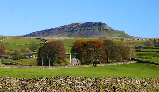
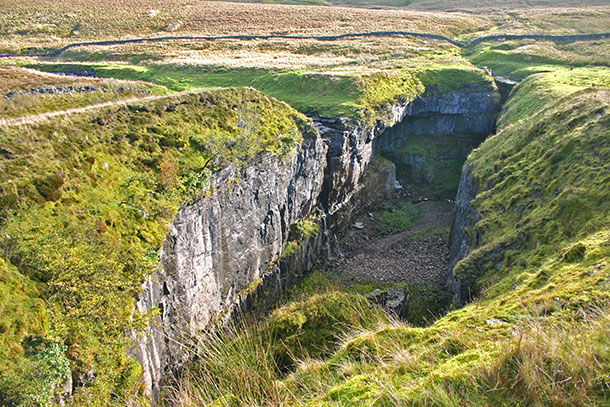
Someone once told me that Hull Pot was the biggest natural hole in England… mind you, another person told me that Birmingham was the biggest hole in the country but they could have been alluding to something different. Without a person in the shot it’s difficult for viewers of the photo to imagine the scale of this chasm – which can come as something of a shock to the unwary as they march along the path from Horton-in-Ribblesdale to Foxup beneath Penyghent. It’s around 90m long and 30m wide with sheer drops all round – and no warning signs. I thought the waterfalls might have been more impressive this morning after all the recent rain but it wasn’t to be, and I’ve yet to capture them in full flow. Today I headed back to Horton via the Pennine Way down Ribblesdale where the views across the valley were gorgeous. Here a cloud has just enveloped the top of Ingleborough.
It’s a shame you can’t hear this photo. I popped out for a bit of air at lunchtime, despite the rain, to see how Stainforth Force was looking. I could hear the mighty thundering of the Ribble from several hundred yards away; standing beside the fall it was deafening. Perhaps it doesn’t look so impressive in the photo but you have to remember that this is normally a short series of falls… at times today it look like one powerful cascade – and incredibly there were salmon trying to leap against the flow. Daft beggars.
The packhorse bridge here is one man-made structure no one could ever object to in the dales.