Ingleborough: peak viewing

Ingleborough2

Ingleborough is once again the focus of my blog this week although it didn’t set out that way… A bit like the myths surrounding Giggleswick’s Ebbing & Flowing Well (mentioned in my blog of 06/03/16) the legend of Robin Hood’s Mill, just a couple of miles away, arose because of the area’s geology. Just off the Stackhouse road from Little Stainforth to Giggleswick, near the parish boundary, there is a hollow which according to local folklore was the site of Robin Hood’s Mill. The tale goes that Robin was a miller who worked all hours and even on Sundays. As a penance for working on the Sabbath, the weight of his clanking machinery sank further and further into the ground until it completely disappeared from sight. It was said that if you put your ear to the ground, you could still hear the millstones grinding deep below. Before the last war, cavers explored the hole and also heard the rumbling sound. Afterwards, the noise seemed to stop; it is likely that the noise was gurgling water and that the cavers’ excavations merely created more of a sound barrier.

ingleborough 4

ingleborough3

These photos were taken close to the ‘mill’ last Sabbath while I was out working on photographing my patch – I wonder what fate awaits me.

Ingleborough1

The snow was still laying deep on the higher hills as I walked into Settle on Monday from Langcliffe. White-topped Ingleborough contrasted starkly against the greener lower dale.

ingleborough 5

The donkeys in a field above Settle are becoming local celebrities with many walkers heading up the steep gradient from Constitution Hill on the Malham trail using the sight of the animals as an excuse to stop and draw breath. They were sunning themselves against the wall. My comments on twitter and Facebook brought in hundreds of likes and retweets:
‘You see, young un, this is why we have front legs shorter than those at the back,’ says the top donkey.
‘But Mum, when I want to warm t’other side I fall over,’ replies the youngster.

ingleborough donkeys

On a clear day…

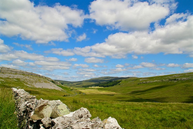
Later in the day I drove to Tatham Fells and then on to Kingsdale (first pic in blog) to view the majestic Ingleborough from other angles. The panorama from the Great Stone of Fourstones, just above Bentham, was the clearest I can recall seeing. The Three Peaks and Gragareth looked splendid but such was the clarity that the Lakeland Fells seemed within touching distance.

ingleborough lakefells

ingleborough 6

Back down in Ribblesdale I couldn’t stop myself taking yet another photo or two around St Oswald’s in Horton.

ingleborough 7pyg

More dramatic

After a couple of days stuck mainly indoors I headed up to Ribblehead Quarry to stroll around part of the Ingleborough National Nature Reserve. Yet another angle on Ingleborough showed some melting of the snow had taken place but you certainly wouldn’t describe it as spring-like! Whernside and Penyghent weren’t to be ignored, of course; the limestone pavement and quarry rocks provided interesting foregrounds.

ingleborough whernside

ingleborough 8

ingleborough penyghent

New life

The deaths this week of a former work colleague, followed by a cherished family member, has left me somewhat deflated. I was cheered a little by the sight of new life though in the local fields where lambs gambolled without a care in the world. So many new things to discover and adventures to be had. Oh to have that innocence of youth again. The lamb on the right reminds me of my own childhood – my mum was always having to sew knee patches on my trouser legs, too!

ingleborough lambs

Fire-breathing monsters in Ribblesdale

ribblesdale - coverdale

I love maps. From where I’m typing this in my Ribblesdale cottage I can see about 20 of them, balancing precariously on a shelf. I have an 1841 tithe map of Langcliffe framed and hung on a wall. I often read maps instead of a books; I’m forever scouring them for new features or to compile fresh walks. There’s probably a polite name for someone with such an obsession. But I wonder if the end of the large folded paper map is upon us. I hope not. This week the OS were trying to flog a new deal for online mapping for smartphones. You can get unlimited mapping plus a host of other clever do-dahs for an annual fee. I can’t afford a smartphone or indeed yet another annual fee, so when I’m out in the Dales I’ll continue to bumble along in my quaint old-fashioned way – so I hope they are kept up to date. One day last summer I was out on the moors above Dent, sitting on a rock, eating a sandwich and reading a map. A couple of hikers approached me and asked for guidance because their gizmo had ‘died’. Smug, is how I would describe my mood that day. They were foolish not to take a proper map – no batteries required.

Ribblesdale mayhem?

ribblesdale - train

In last week’s blog I went off on one about HS2 and how the high-speed railway will destroy much countryside just to cut a few minutes off a journey. I compared my anger to that of people of Ribblesdale when the Settle-Carlisle line was cut through the dale. Out of interest (it was raining again) I pored over a pre-railway OS map of the route – published in 1842. As much as I admire the engineering feat needed to take the railway through some very tricky parts of Ribblesdale, its construction must have caused mayhem. And let’s face it, as much as many people enjoy seeing the big old steam locos chugging up and down the line today, residents at the time would have dreaded the great fire-breathing monsters spewing out filthy smoke and making a noise like a herd of rampaging elephants. The incline from Settle to Ribblehead passes over some tough terrain – everything from solid rock to boggy marshes. Much of the work was done manually as the line inched up Ribblesdale; so hats off to the poorly-paid workers whose section is still providing services.
The same can’t be said about the route further north, near Appleby, where ground saturated by unprecedented rainfall has become unstable. The line could be closed for several months for repairs. I hope this doesn’t put passengers off coming to Ribblesdale or using the line between Leeds and Appleby. http://www.settle-carlisle.co.uk
I hope too that there is a good service available by April 29 when the Tour o’ Yorkshire (I’m refusing to use the ‘de’ – what’s it got to do with the French?) comes to the area. There will be a public meeting at Victoria Hall, Settle, on Monday Feb 29 (6pm) to discuss local plans.

ribblesdale - snowdrops

Lovely to see snowdrops appearing around the village once again. Their brief show is said to herald the arrival of spring. I suspect as usual in these parts that their appearance is premature.

ribblesdale - watlowes

I snatched an hour or so out on the fells above Malham one bright breezy day this week. Hardly a soul to be seen as I wandered along the Pennine Way between Watlowes valley and the Tarn, normally quite a busy trail at the weekend. Note to self: do this walk in the morning so as not to get the dark shadow on the west slope of Watlowes. The Tarn took on a deep dark blue hue when viewed from a little knoll just off the path.

ribblesdale - malham tarn

Mind clearing

When my head is full of all sorts of daft stuff I’ll often drive the car over to Halton Gill on the Stainforth road to try clear my mind. There are only half a dozen farms from one end to t’ other along the seven miles or so. The landscape and views are breathtaking. I get out of the car, mooch about, find a new spot from which to take a photo, or as on Friday sit and stare at two daft beggars cycling up that incredibly steep hill from Halton Gill.

ribblesdale - haltongill
The light changed rapidly as the clouds scuttled across lovely Littondale. For a few seconds the tiny hamlet was bathed in sunshine. Behind it, the domineering moors switched from moody browns to inviting orange, while the tops kept on their dreary, misty hats.
The smaller, less populated dales have always appealed to me – Kingsdale, Coverdale, Raydale, to name but three – and they’re all firmly on my to-do-again list in spring. The top picture in the blog was taken from Coverdale, looking back down the valley towards Wharfedale. Here’s one looking across Kingsdale.

Ribblesdale - kingsdale

Well, it’s St Valentine’s Day again and in true Yorkshire bloke fashion I say ‘thank goodness I don’t have anyone to waste mi brass on’. I expect all my cards and gifts will arrive via a fleet of home delivery vans tomorrow, it being Sunday today.

Steamy memories, upsetting sights, gates and idiot drivers

Why do some drivers hurtle through the Dales like they’re on an audition for a Top Gear presenter slot? I was forced off a narrow lane by two idiots driving shiny new petrol-guzzling Range Rovers one day this week. They were obviously not the local farmers who once again have had to put up warning signs along the lovely road between Stainforth and Halton Gill. It should be obvious to most sensible people that farm stock (and children) wander around the countryside. And the views are fantastic – so why dash through like demented rats?lambsroad

While not a rat – I’m not sure what it is actually (mink?) – this dead creature in a cage is perched on a wall near Giants Grave beneath Fountains Fell. I’m uncertain what point is being made by leaving it here for all to see. Perhaps someone in the know could enlighten me. It certainly met a gruesome end.

mink?
Nearby is something much more pleasant – Nature’s garden, a colourful limestone rockery and stream with Penyghent in the background. No need for a trip to the smoke to see those pretend – or should that be pretentious – gardens at Chelsea.
streampyg
Kingsdale, where I visited on Wednesday, is short and sweet; a hanging valley swung like a hammock between Whernside and Gragareth. A narrow squiggly road runs beside Kingsdale Beck – a flow of water with a real identity crisis. It quickly assumes the name River Twiss before joining the River Doe at Ingleton; later it forms the Greta and then the Lune at Kirby Lonsdale before heading for the Irish Sea.
A couple of farms are the only signs of human habitation in the dale while four gates on the road between the head of the dale and neighbouring Deepdale help slow down any over-eager motorists. Here I go again… but why would anyone want to speed through this breathtaking countryside?
kingscloudhowgillwide
Leaving the loneliness of Kingsdale behind, the lush greenery of Deepdale opens up before you at the road’s 1570ft summit. I pulled in where a track leads over to Barbondale (a trip for another day) and now the camera goes into overdrive. The contorted Howgills (pictured above) to the west seem to grow with every step up the track. In front of me, Deepdale joins Dentdale on stage and the great mass of Aye Gill Pike provides the dramatic  backcloth. The steep slopes of Deepdale Side and Whernside help shelter the scooped-out valley of Deepdale from the strong easterly winds. Farmers are busy making hay while the sun shines (not a euphemism for anything).
‘Must get myself a gate-opening passenger’ (again not a euphemism for anything seedy) I mutter after closing the fourth gate before winding slowly down the narrow road to Cowgill.
farmdeep
There are some interesting ancient bridges down this part of the dale, one near the Sportsman Inn which is in constant need of repair due to persistent misjudgements by motorists (yes, a further moan about them). Another bridge, near the tiny church which is worth a visit, contains a stone plaque which reads:
THIS
BRIDG REPER
ED AT THE
CHARG OF TH
WEST RIDING
D 1702
Either the original stonemason didn’t plan his work properly or later repairs have obscured part of the wording – but we get the gist.
cowbridge
In the late 1950s, early ’60s, along with many other boys, I would stand on a railway bridge and wait for a steam train to pass underneath. We’d get covered in smoke, steam and soot and that would be considered time well spent in the days before girls and t’ internet came along. To evoke those memories I  stood on a bridge at Stainforth this week and waited eagerly for The Dalesman train. For any other sad fools like me, visit this link to see my very short video.
https://youtu.be/H4Uc3Cv4CfU
I also managed to capture Galatea near Langcliffe to satisfy those who moaned about not having any train material in last week’s edition of my ‘wot I did on my hols’ summer blog.

galatea

Put a Dent in your day

dent

Felt the urge to visit Dent today – I just fancied that lovely drive up Ribblesdale towards Hawes before dropping down into delightful Dentdale. I had lunch in this far-flung outpost of the West Riding and took a few stock pictures of the cobbled streets before heading over to Ingleton on the Kingsdale road. This must be one of the best roads in Yorkshire – despite its narrowness and there being several gates to open and close. (Note to self: get a mug, I mean companion, to come along next time.) The views are stunning and the waterfall, although gentle today, is an added bonus.

falls1

Pressed cheese and icy toppings

cheese press

Clear blue skies tempted me into clambering up the rocky western side of Kingsdale this morning. The views were fantastic. I went as far as the Turbary Road, an ancient track which locals once used to collect peat from the slopes of Gragareth. To the west I could pick out Morecambe Bay across the Lune Valley, and the snow-topped southern fells of the Lake District. Just off the main track are these erratics known as the Cheese Press Stones where I ate my pressed cheese sandwich while staring towards Ingleborough and Whernside.

Dales light show – part two

rainbow

kingsdale

Here’s the rainbow talked about in my last blog. You may not be able to see in this small copy of the photograph but on the left is part of a ‘double’ rainbow – a reflection of the strong rainbow on the raindrops. The other photo shows a ray of late sunlight flitting down Kingsdale with Ingleborough and rain clouds in the background.

Putting Yorkshire in the frame

A great idea by Ashley Jackson @AJacksonArtist see #puttingyorkshireintheframe Where do you begin? Yorkshire has so many gob-smacking viewpoints and each dale has its own distinctive feel. How about some recognition for the minor dales like the three here… views down Silverdale, above Garsdale and from Kingsdale over Dentdale.

silverdale

garsdale

kingsdale

%d bloggers like this: